The Goldfields Road must be one of Western Australia’s most undersold, under hyped, under promoted and least appreciated journeys.
This 500 kilometre Track follows the York to Goldfields Heritage Trail.. ..not to be confused with the Golden Pipeline Trail which is a 650 kilometre trail from Mundaring Weir to Kalgoorlie.

The start of the Goldfields Road is six kilometres out of York along the Northam-York Road, however, it is worthwhile to call into the Information Bay on the Great Southern Highway 1.2 kilometres west of York where there is extensive information about the route.
And while this Road Trip did not slavishly follow the Goldfields Road, it covered enough of it to get an appreciation of its value.
From an initial 20 potential starters, we left El Caballo, 50 kilometres east of Perth, at 4.30 p.m. with 12 people in eight vehicles.
It was starting to get cold when we arrived at Mindebooka Hill and set up camp. And the forecast was for zero and below.
-

- Mindebooka Hill
Yep, the forecast was correct! Next morning it was good to get into the vehicle and away.
First task for the day was to refurbish Burracoppin Well.
Steam Train Historic Site
After we were satisfied with the job at the well we headed to an historical site, two kilometres north-west of Burracoppin. It appears to have been a water supply for the railways when steam trains were in use.
Immediately on arrival we did some testing of approach and departure angles.
-

- Tony and Cherry in the Navara.
-

- Steve takes his vehicle across the gutter.
-

- Mike and Harrison in the Jeep.
-

- Kevin takes his vehicle through gutter.
We found another, steeper embankment and Jon negotiated the Patrol over it and the associated gutter.
-

- Patrol straddling gutter.
-
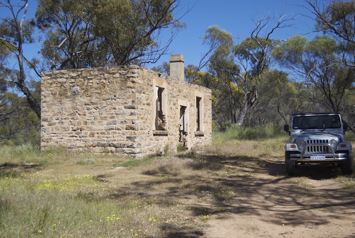
- Ruins of what was possibly the caretaker or manager’s residence.
-

- Filled in well behind ruins.
-

- Greg and Margot in Colorado.
-

- Jon’s Patrol.
-

- At the manager’s residence ruins.


Ephemeral, Unnamed Lake
Even after testing approach and departure angles, investigating the ruins of an historic building, and a dam there was still a huge chunk of time to fill in so we headed north towards Lake Campion. Along the way we tried a shortcut through the Conservation Reserve and came across an ephemeral lake – now nearly full.
-

- In Lake Campion Conservation Reserve.
-

- Newly formed lake.
-

- Joe at lake.
We returned to Lake Campion Road and headed north, intent on having lunch at the site of the Chandler Potash/Gypsum Works that were in operation from 1942 to 1952. It took me some time to locate it – it had been radically altered from when we were there last only 12 months earlier.
Chandler
-

- Disused overhead tank near Chandler.
-

- Remains of Chandler.


It would appear that the intent in ‘cleaning up’ the site was the removal of steel/iron. And, while the site has been cleaned up, it is very short sighted that such heritage items have been removed. The site was so different that I did not at first recognise it as I drove past and consequently spent 30 plus minutes looking for it. And then those who had not been there before were wondering what all the fuss was about. On the evidence presented to them – nothing.
-

- Lake Chandler
-

- Jon’s Patrol.
-

- Blue tongue skink rescued from peril.
-

- Leaving Chandler.
At cents in the dollar for scrap steel versus the heritage value of the site it makes one wonder at decisions made.
Mindebooka
After lunch we drove into Merredin to refuel and then took the Bruce Rock road south to Totadgin Well. Along the way we stopped at a Main Roads WA Network Performance Site.
-

- Network Performance System marker.
Jon explained to the group how NPS works. We moved a few kilometres south to Totadgin Reserve for our second well refurbishment project.
Job completed, back to camp. Views of Baandee Lakes along the way.
-

- Mindebooka Rock
Joe prepared and cooked a damper that he shared with the group. Excellent.


Metchering Well
We packed and left our camp at Mindebooka early on Sunday morning and drove to nearby Metchering Well. It is on private property and I had already contacted the owner and received permission to enter the property.


Doodlakine Well Clean Up
From Metchering we headed north to Doodlakine Well to clean it up. The well is located in a Reserve, where ‘Old Doodlakine’ was located on what is now Goldfields Road.
After cleaning up Doodlakine Well we headed west on Goldfields Road and stopped at Happy Dolphin Rock. Looks nothing like a shark.
The wattle trees were blooming.


Just down the road is Marranobbing Well.
Leaving the Goldfields Road we drove through Kellerberrin and continued south towards Kokerbin Rock. Jon left us at this point for an appointment in York.
The scenic route around the eastern base of Mount Stirling is a very interesting drive.
Kokerbin Rock
Kokerbin Rock is the third largest monolith in Australia – after Ayers Rock and Walga Rock (although that is disputed).

On the south-western side of the rock is a fine example of a dry rock pioneer well.

From Kokerbin we returned home through Pantapin, Quairading, and York.
© Kim Epton 2016-2024
879 words, 44 photographs.
Feel free to use any part of this document but please do the right thing and give attribution to adventures.net.au. It will enhance the SEO of your website/blog and Adventures.
See Terms of Use.
