-
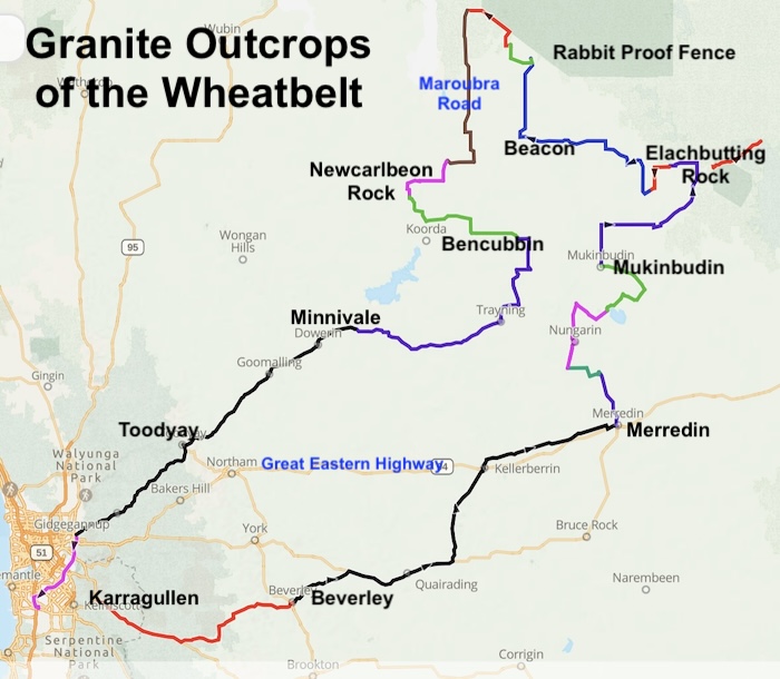
- MAP OF COURSE GRANITE OUTCROPS OF THE WHEATBELT
Day 1
Karragullen
Beverley
Quairading
Kellerberrin
Goldfields Road
Merredin
Merredin Hill
Danberrin Hill
Day 2
Nungarin
Mangowine
Eaglestone Rock
Wiera Nature Reserve
Mukinbudin
Day 3
Wattoning
Elachbutting Rock
Sandplain Track
Berringbooding Rock
Bonnie Rock
Wialki
Beacon
Billiburning Rock
Day 4
Tampu Well
Beagleys Breakaway
Rabbit Proof Fence
Maroubra Road
Clearly Rocks
Mollerin Rock
Newcarlbeon Rock
Bencubbin CP
Day 5
Marshall Rock
Pergandes Sheep Yards
Wiacubbing Hill
Waddouring Dam
Trayning Gnamma
White Man Rock
This isolated, unusual and little known quartz rock has a seminal place in Western Australian goldfields history. The rock is accessed via Moujakine Road. The historic Moukakine Well is at the same location.
The discovery a small nugget of gold at Moujakine Well/White Man Rock early in 1887 eventually led to the discovery of the Golden Valley goldfield which sparked off the Yilgarn gold rushes.
Lake McDermott.
Minnivale
Day 6
Dowerin
Goomalling
Toodyay
Middle Swan
Jandakot
The Granite Outcrops of the Wheatbelt Road Trip was in April 2026 during the fuel crisis caused by the closure of the Strait of Hormuz.
Distance 0000 kilometres.
Road Trip 1015 – Granite Outcrops of the Wheatbelt. Download GPX File.
© Kim Epton 2026
159. words.
Feel free to use any part of this document but please do the right thing and give attribution to adventures.net.au. It will enhance the SEO of your website/blog and Adventures.
See Terms of Use.
