
Westernmost Point
This extremity marker (more technically a stele) at the Moei River, Mae Sot is widely inaccurate.
-

- While for most of its length the Moei River forms the Thailand western border, the actual westernmost point is 124 kilometre further west and 244 kilometres further north on the Myanmar border.
While for most of its length the Moei River forms Thailand’s western border, the actual westernmost point is 124 kilometre further west and 244 kilometres further north on the Myanmar border.
The Westernmost Point of Thailand is at 18.57691, 97.34310. It is the western boundary of the Salawin Wildlife Sanctuary. The nearest Thai village Ban Mae La Luang, is 62 kilometres to the east.
Northernmost Point
The Northernmost Point of Thailand is erroneously stated by various sources to be in Mae Sai, Chiang Rai Province.
While the town of Mae Sai is widely advertised and marked as the northernmost point, there is a distinction between the symbolic marker and the actual geographic extreme.
Mae Sai is the end of Highway 1 and it is the northernmost town in Thailand but it is not Thailand’s northernmost point. A prominent archway is located in the town centre at the end of Phahonyothin Road (Highway No. 1). This is the popular tourist spot for photos, situated right next to the Mae Sai River bordering Myanmar. This tourist spot in Mae Sai is referred to as the “Northernmost Point of Thailand Monument” (อนุสรณ์สถานเหนือสุดแดนสยาม) or simply the Northernmost Point Sign.
-
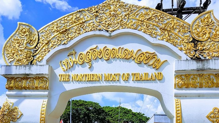
- At Mae Sai.
The Actual Geographic Point is nine kilometres north-east at the confluence of the Mae Sai River and the Ruak River. This spot is marked as the ‘North Pole Point’.
The Northernmost Point is at 20.46485, 99.96036.
Easternmost Point
The Easternmost Town of Thailand is Khong Chiam in Ubon Ratchathani Province.
While not the absolute Easternmost Point, Pha Cha Na Dai (Face the Sun) Cliff is famous for being the first place in Thailand to see the sunrise each day (wth numerous others), overlooking the confluence of the Mekong River and the Mun River. Pha Cha Na Dai Cliff is in the Pha Taem National Park.
-
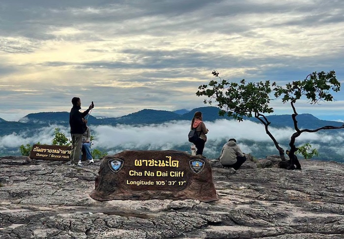
- Cha Na Dai Cliff.
Unlike the made-for-the-tourists northern and southern points which have large steles (monumental arches) in town centres, the easternmost marker (also made for tourists) is integrated into the natural cliffside viewpoint infrastructure and indicates the longitude (105° 37′ 17″ E).
The Easternmost point of Thailand is 15.65136, 105.63510 just east of Ban Pak La.
Southernmost Point
The Southernmost Point of Thailand is located in Betong District, Yala Province, at the border with Malaysia.
The site for tourists is marked by a prominent marble extremity marker (stele) engraved with a gold lettering inscription paired with a golden map graphic stating “The Southernmost Point of Siam” (ใต้สุดแดนสยาม). This marker is located directly at the border checkpoint infrastructure.
While the town of Betong itself is widely marketed as the “southernmost city,” the actual geographic extreme is at Bukit Kobeh (also known as Khao Ko Be in Thai). This is a prominent hill located in the Titiwangsa Range, straddling the border between Perak, Malaysia, and Thailand. Standing at an elevation of 896 metres it is the southernmost point of Thailand.
| Direction | Tourist Marker | True Point | Distance |
| West | Mae Sot marble stele | Near Ban Mae La Luang | ~124 km further west (~244 km overall) |
| South | Malaya–Thailand Border Stone, Betong | Bukit Kobeh | ~19.1 km SE |
| East | Pha Cha Na Dai Cliff | Near Ban Pak La | ~4.0 km N |
| North | Mae Sai archway | Mae Sai–Ruak confluence | ~9.0 km NE |
© Kim Epton 2026
605 words, four photographs.
Feel free to use any part of this document but please do the right thing and give attribution to adventures.net.au. It will enhance the SEO of your website/blog and Adventures.
See Terms of Use.