Yilgarn Craton – Ancient Landscape

The Yilgarn Craton in Western Australia is one of the most ancient landscapes preserved anywhere on Earth. It is where most of our trips take place.

The Yilgarn Plateau is a large stable block of the earth’s crust, one of the original masses of rock that rose out of the sea in the Late Archaean, about 2700 mya to form the original landmass of Australia. At this time the eastern part of Australia had yet to form. Yilgarnia is the name given to the land surface of the Yilgarn Craton.

The 65,000 km2 of the Yilgarn Craton lies in the southern part of Western Australia, from Meekatharra and Wiluna in the north to the south coast and from Yamarna and Balladonia in the east to just short of the west coast. The Darling Scarp forms a clear-cut line that separates it from the much younger Swan Coastal Plain along its western edge. The Darling Scarp is the edge of the rift formed at the beginning of the separation of India from Australia, which preceded the separation of Australia from the present continent of Antarctica about 45 million years ago during the break up of Gondwana.

The Yilgarn Block has not been submerged since it rose out of the sea. It was one of the blocks of crust, cratons, which were later joined together to form the present continent of Australia, at a much later date.

Further reading:
http://austhrutime.com/yilgarn_craton.htm

© Kim Epton 2016-2024
272 words.

Feel free to use any part of this document but please do the right thing and give attribution to adventures.net.au. It will enhance the SEO of your website/blog and Adventures.

See Terms of Use..

Centre of Western Australia

The Geographic Centre of Western Australia is on Glenayle pastoral station, 970 kilometres north-east of Perth, on the edge of the Little Sandy Desert.

The closest town of any size is Wiluna, 260 kilometres south-west. The centre is east-south-east of the Glenayle Homestead and north-east of the Glenayle – Carnegie Road. The closest point on the coast from the centre is a remote beach near Port Hedland, 640 kilometres to the north-north-west. The WA/NT border is 670 kilometres due east. To the south is Esperance, 950 kilometres distant.

By any measure it is remote.

Access to the Centre from Wiluna is through Wolgawol Station to Glenayle Station on the western edge of the Little Sandy Desert/Great Victoria Desert. South of the Centre is Carnegie Station and Prenti Downs.

The location of the  Centre of Western Australia is:
25° 19′ 41″ South, 122° 17′ 54″ East
-25.32806, 122.29833
51J 429383 7198541

The ‘centre’ of any piece of geography is indefinite and subject to discussion, depending on the method used to determine it. Other factors such as tectonic plate movement also need to be considered. The coordinates stated above are those provided by Geoscience Australia, converted from 1966 datum to 2020 datum.

Read more at Geoscience Australia.

We marked the centre of Western Australia in 2022.


© Kim Epton 2022-2024
249 words, one photograph.

Feel free to use any part of this document but please do the right thing and give attribution to adventures.net.au. It will enhance the SEO of your website/blog and Adventures.

See Terms of Use.

Harvesting Water

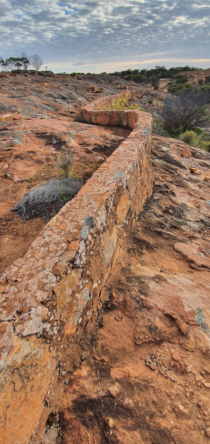
The numerous granite outcrops throughout Western Australia’s agricultural regions are a valuable source of water if the runoff can be captured or ‘harvested’.

Many of these granite outcrops, particularly eastward towards Kalgoorlie and beyond, have had low walls, typically 300-500mm high, erected on a selected contour of the outcrop that channels water flow into another channel or a culvert and ultimately into a reservoir or tank located lower down the rock. Many of these reservoirs were roofed to slow down evaporation.

The harvest walls that aggregate water from the rock and the channels that then direct the precious liquid into a tank or dam are invariably fine examples of stonemasonary.

Wave Rock (more correctly Hyden Rock) is probably the most famous rock to be harvested. Clever photographers avoid including the wall at the top of the wave in their photographs.

Water harvesting and collection in tanks was often for community water supplies but the most common use was for the boilers on steam trains.

The amount of water harvested from a granite outcrop depends on the size, steepness and shape of the rock. Estimates of runoff at, for example, Karalee Rock are that a 25mm/hour downfall would have a runoff of 6200L per acre.

Reference
Laing, I.A.F. and Hauck, E.J., Water harvesting from granite outcrops in Western Australia, Journal of the Royal Society of Western Australia, 80: 181-184, 1997.


© Kim Epton 2019-2024
292 words, two photographs.

Feel free to use any part of this document but please do the right thing and give attribution to adventures.net.au. It will enhance the SEO of your website/blog and Adventures.

See Terms of Use.

Boab Trees

Boab trees are of the genus Adansonia. In Africa and Madagascar these trees are known as baobab. The Australian species Adansonia gregorii (named in honour of explorer Augustus Gregory) has been evolving for 190 million years. They are thought to have originated from plants washed ashore from Madagascar, although this is not universally accepted. They are now considered to be native to Western Australia.

It is sometimes claimed that the boab is the oldest living thing in Australia. But –  stromatolites!

Boab trees grow to a height of 15 metres although 9-12 metres is more usual. The drop their leaves during the dry winter of northern Australia. These trees are found throughout the Kimberley, extending into the Northern Territory.


© Kim Epton 2021-2024
161 words, one photograph.

Feel free to use any part of this document but please do the right thing and give attribution to adventures.net.au. It will enhance the SEO of your website/blog and Adventures.

See Terms of Use.

Man in the Moon Crater

Shoemaker Crater is about 100 kilometres north-east of Wiluna.

This impact crater was formed some time between 500mya and 1.6bya, depending on which source you believe. At that time there were no plants, no animals and no fungi – only stromatolites. A very different planet from today. A 2600 metres wide asteroid hit outback Western Australia at a speed of 65,000 kilometres per hour, creating a 30 kilometres wide impact that was identified as an impact crater in 1974.

It is estimated that the resulting explosion was the equivalent of 784 megatons (about 15 x larger than Tsar Bomba – the largest nuclear bomb ever detonated) and generated an 8.5 magnitude earthquake. The heat and thermal radiation would have destroyed any lifeforms  for a 500 kilometre radius.

The crater was named after Eugene Shoemaker (1928-1997) a renowned US planetary geologist who was killed in a vehicle crash on the Tanami Track in the Northern Territory. His ashes were on the Lunar Prospector when it was deliberately crashed into Mawson Crater near the South Pole of the moon in July 1999. The International Astronomical Union then renamed the crater as Shoemaker Crater.


© Kim Epton 2022-2024
219 words, one photograph.

Feel free to use any part of this document but please do the right thing and give attribution to adventures.net.au. It will enhance the SEO of your website/blog and Adventures.

See Terms of Use.