Great Western Woodlands

The Great Western Woodlands is an internationally significant area of great biological richness.

It is the largest remaining area of intact Mediterranean climate woodland left on Earth – comparable to Africa’s Serengeti.

Covering almost 16 million hectares – about the same size as England – it is a continuous band of generally eucalypt woodlands (as opposed to forest) and heathlands interspersed with salt lakes, granite outcrops and in the north-west, banded ironstone formations ranges. It stretches from the edge of the Wheatbelt to the Eastern Goldfields and pastoral rangelands to the north, the inland deserts to the north-east (mulga dominated) and the treeless Nullarbor Plain to the east. It includes the higher rainfall coastal heath to the south east, and agricultural land to the west and south. It connects the south-west corner of Australia to the inland deserts.

The Wilderness Society published a very informative Report on this ecological treasure titled The Extraordinary Nature of the Great Western Woodlands and continue to work for its health and preservation.

More than 20% of Australia’s native plant species and 20% of Australia’s eucalyptus species exist here.

A community of animal species threatened elsewhere in Australia find a unique haven in the Great Western Woodland. These woodlands provide a refuge for many threatened wildlife species found nowhere else on the planet.

The Great Western Woodlands provides a home for numerous bird communities that have been in decline in many parts of Australia as a direct result of habitat destruction and fragmentation. It is home to 33% of WA’s birds and 18% of Australia’s birds according to a Birdlife Australia survey of the Woodlands’ bird population from 2012 to 2014.

The Great Western Woodlands is a largely intact ecosystem predominantly located on public lands. Poor fire management, feral animals, weed encroachment, and human activities including road construction and mining, are all threats to to the Woodlands.

“The Great Western Woodlands forms an area of global mega-diversity and supports some of the world’s most unique and vulnerable ecosystems.”


© Kim Epton 2015-2025
368 words, one image.

Feel free to use any part of this document but please do the right thing and give attribution to adventures.net.au. It will enhance the SEO of your website/blog and Adventures.

See Terms of Use.

Elachbutting Rock – a Wheatbelt Wonder

Elachbutting Rock is the most impressive of all the huge granite outcrops in the Wheatbelt.

It is a large granite monolith that sits in the middle of a pristine nature reserve on the edge of the Wheatbelt, 70 kilometres north-east of Mukinbudin.

Naming of the Rock

The official name for this rock was provided by Surveyor H.S. King in 1889. Of aboriginal derivation its meaning is unknown although ‘that thing standing’ is a possibility. Explorer B.D. Clarkson named it Mount Bucket during his exploration of the area in 1864 – quite possibly a lazy interpretation of the aboriginal name for the feature. Clarkson’s name for the rock didn’t survive and the current difficult-to-pronounce name (one of several English spelling renderings of it) is totally non-marketable for a feature that should be better known.

Compare with Wave Rock – where the savvy marketers in the south-east wheatbelt town of Hyden rejigged the bland ‘Hyden Rock’ to a much more marketable description of what is now a great tourist attraction. And latterly, a crappy salt lake common to anywhere in the Wheatlbelt as ‘Lake Magic’. Maybe some local interest group around Mukinbudin or Westonia will recognise the tourist potential of Elachbutting and nearby granite outcrops, apply more marketable names, and reap the rewards of increased visitation to the area.

Montys Pass

One of the features of Elachbutting is Montys Pass, where a huge chunk of the rock’s outer layer has dislodged and slid down, leaving a 30 metre walk-through tunnel between the rock and the dislodged chunk.

At the end of this is Kings Cave, which in reality is a large tafone. Many granite outcrops (inselbergs or monadnocks) have tafoni.  Uluru and Kata Tjutu are well known examples.

Fifty metres to the south of Montys Pass is a wave formation that, while it does not quite rival Wave Rock, is still impressive.

The lookout on top of the rock is accessible by 4WD and provides fantastic views across farming land.

There are many great camping spots at the rock.


The reports of the various trips, tours and travels on the Adventures website have a lot of information about place names – their naming and features – toponymy. More information.

© Kim Epton 2017-2024
418 words, four photographs.

Feel free to use any part of this document but please do the right thing and give attribution to adventures.net.au. It will enhance the SEO of your website/blog and Adventures.

See Terms of Use.

Overlanding

In Australia there is not much difference between Overlanding and long distance Road Trips.

Overlanding is often defined as travel to more remote and less frequented places on mostly unsealed roads or tracks. See above.

Overlanding journeys can be as long as required (permanent lifestyle touring) or as short as perhaps ten days. Some people suggest that Overlanding is more about the journey than the destination, however, in Australia, virtually by default, the journey to most of the country’s iconic destinations entails long distance, self sufficient, off grid travel and camping (Overlanding). Overlanding in Australia can take you to some truly iconic destinations.

Slowly the best kept secret in the overlanding/4WD touring world – Western Australia and its vast open distances, beautiful beaches, amazing gorges, incredible national parks, remote deserts, and stunning coasts – is becoming more widely known. Our isolation as a remnant of Gondwanaland in the Southern Hemisphere has so far protected our pristine environment and ensures that anyone can have a world-class outdoors experience.


© Kim Epton 2024
198 words

Feel free to use any part of this document but please do the right thing and give attribution to adventures.net.au. It will enhance the SEO of your website/blog and Adventures.

Jimbine Rockhole

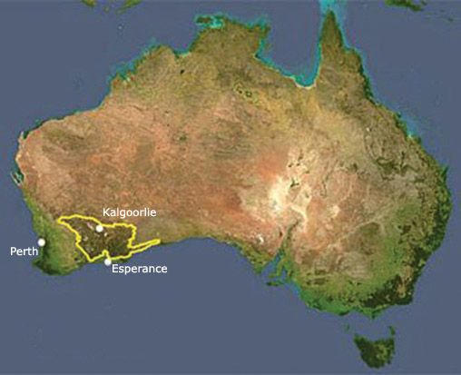
Jimbine Rockhole is a rarely-visited, aboriginal water source in the Helena and Aurora Range. It is not listed in official records.

The following text and photographs have been extracted from Lesley Brooker’s excellent book, Explorers Routes Revisited – Clarkson Expedition 1864:

“According to Harper, the party crossed the range about 8 miles north-west of Mount Kennedy, and the continued on for another 5 or 6 miles. Therefore, I calculated that Jimbine must have been somewhere in the vicinity of 30o17’S, 119o35’E. Consequently Michael and I circumnavigated the Helena and Aurora Ranges to this approximate location on the northern side.  Finding nothing near the track we began a search on foot.  About 100 m east of the track, on scalling a low rise, we were astonished to find a clearing in the next valley that contained a natural well in the conglomerate sandstone, exactly as Harper had described it.

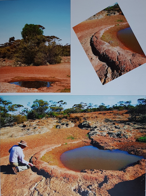
Jimbine is on an open gravelly hillside with outcropping laterite and fringed with open woodland. The rockhole itself measured from 2 to 3 metres in diameter and held water to the depth of at least 1 metre.  It was fed by a small eroding drainage line from a rise to the south.  The lower perimeter of the well was composed of reddish sandstone, with a relatively smooth, rounded rim, which was so regular that one could almost believe that it had been worked to give it that finish. Surrounding the well for at least 300 metres on all sides, the ground was covered with broken, worked flints.

There was no sign of European interference with the site and nobody had visited it recently. From the hillside beside the rockhole, the peak of Mount Kennedy (Bungalbin) could be seen to the east of south, 12 kilometres away.

Clarkson, Harper and Lukin would camp at Jimbine for the next three nights, while making daily forays to the surrounding areas and so I imagine that the rockhole may have deeper in their day, kept free of debris and sand by the local Balcup Aborigines.”

The name Jimbine is not in Geonoma, Landgate’s database of geographic names.  Most of the names used by Clarkson, Harper and Dempster were either changed or ignored by the authorities at the time.

Reference:
Brooker, Lesley, Explorers Routes Revisited – Clarkson Expedition 1864, Hesperian Press, Carlisle, WA, 2012, p60-61.


© Kim Epton 2017-2024
428 words, two images.

Feel free to use any part of this document but please do the right thing and give attribution to adventures.net.au. It will enhance the SEO of your website/blog and Adventures.

See Terms of Use.


Insect Repellents

Notes/Disclaimers

No single commercially available insect repellent is effective against all the biters that are likely to be encountered in Australia.

Different species of flies and mosquitoes react differently to particular repellents and therefore more than one product may be needed to stay bite-free.

No insect repellent will deter stingers such as bees and wasps.

The information listed here is time sensitive. Manufacturers may have changed the name and/or composition of their products or they may no longer be available.

New, more efficacious products may be available.

Ingredients of Insect Repellents

  • N,N-diethyl-m-toluamide (diethyl toluamide) (deet)

This is a powerful mosquito repellent, particularly against the culcine species, carrier of Murray Valley encephalitis and the Ross River virus.

  • 2-ethyl-1,3 hexanediol (ethyl hexane diol) (e-hex)

This is a good mosquito repellent against the other main group of mosquitoes, anopheline, which carry malaria.

  • di-n-propyl isocinchomeronate

This will repel bush flies.

  • N-octyl-bicycloheptene dicarboximide

This will repel bush flies.

  • bisbutenylene tetrahydrofurfural

Repels stable flies and other biting flies.

  • Pyrethrins

Kills insect on contact.

  • Tetramethrin

Repels and kills insects.

  • Bioresmethrin

Repels and kills insects. 

Application

Coat all exposed skin with the repellent. Mosquitoes will find any point not covered. Some insects will bite through clothing so it is important that the repellent is also applied to clothes. Increase the quantity of insect repellent applied to increase the protection.

Keep away from eyes, nose and mouth and, in the case of deet, away from the groin, skin folds and other sensitive areas. Do not apply to spectacle frames or plastics.

Duration of Protection

The length of protection is dependent on many factors, such as temperature and wind. High temperatures will reduce the duration of protection. Exposure to even a gentle breeze can reduce the length of protection by up to half.

Where clothing rubs on skin, repellent will lost rapidly. Swimming, showering or being rained on will wash off most repellents. Sweating also reduces efficacy (desired effect) and at the same time attracts insects. Obviously, reapply as efficacy reduces.

A good repellent will provide four hours protection under ideal conditions. Wind and water reduce the amount of time a repellent is effective.

BRAND TYPE DIETHYL
TOLUAMIDE
PROPYL -ISOCIN-CHOMERANATE N-OCTYL-
DICARBOXIMIDE
Aerogard Spray 190.0 43.5 10.0
Aerogard Lotion 170.0 49.5 18.0
Aerogard Roll On 114.7 41.8 27.7
Skintastic Spray 69.7 n/k n/k
Rid Cream 160.0 10.0 20.0
Rid Roll On 160.0 10.0 20.0
Rid Spray 100.0 20.0 15.0
Off Spray 190.0 43.3 10.0
Pea Beu Spray 52.2 11.0 11.0
Scram Spray 90.0 (E-hex) 40.0 8.0


© Kim Epton 2013-2025
425 words.

Feel free to use any part of this document but please do the right thing and give attribution to adventures.net.au. It will enhance the SEO of your website/blog and Adventures.

See Terms of Use.