Australia’s Largest Sand Dune System

Descriptions on a number of websites about sand dune systems in Australia often include various unreferenced qualifiers such as “largest landlocked dunes”, ‘largest mobile dunes” or even “largest moving coastal sand mass” often combined with “in the southern hemisphere”. It is difficult to determine the accuracy of these claims and equally difficult not to reject the thought that the claim is made  to ‘hype’ the writer’s story.

Fraser Island is Australia’s largest dune system and, indeed, the largest sand island in the world.

The sand dunes at Eyre, historically referred to as Eyres Sand Patch/Sandpatch (1877) are Australia’s largest single sand dune system. The Eyre Bird Observatory (formerly the Eyre Telegraph Station) is located in this dune system.

These dunes stretch 105 kilometres in length and encompass an area of approximately 1000 km2. The average height of the dunes is 10 metres.

The oft mentioned Bilbunya Dunes are the largest mobile, coastal sand dunes in Australia. Note the qualifiers!!

They are also home to Australia’s largest star dune system. A star dune is one that is subject to wind from three or four directions forcing the sand upwards rather transversely.


References

Queensland National Parks – Kgari

World Heritage Places – K’gari (Fraser Island)

Geonoma, Landgate.

Short, Andrew D., Beaches of the Western Australian Coast : Eucla to Roebuck Bay. A guide to their nature, characteristics, surf and safety, Sydney University Press, Sydney, 2006.

Australian Extremes – Sand Dunes


© Kim Epton 2024
282 words, three photographs.

Feel free to use any part of this document but please do the right thing and give attribution to adventures.net.au. It will enhance the SEO of your website/blog and Adventures.

See Terms of Use.

Why is Wiluna the finish of the Canning Stock Route?

Although Western Australia’s first gold rush at Halls Creek in 1885 was short-lived, it opened up the East Kimberley to the cattle industry.

Gold was discovered in Wiluna in 1896 and at its peak, the Wiluna mine became the largest in Western Australia, supporting 9000 miners. There was a huge demand in the mines for fresh meat. Most of Western Australia’s beef came from the Kimberley. At the time, however, East Kimberley cattle were quarantined due to an infestation of tropical ticks. This gave the West Kimberley pastoralists a monopoly on the beef trade — which caused prices to soar.

In 1905 independent MP James Isdell came up with a bold solution to the tick problem – develop a stock route through Western Australia’s harsh desert country, and drove the cattle to market. Isdell believed the ticks would fall off and die in the hot dry conditions. He was right.

Many in government considered the idea of a desert stock route to be impossible, however, H.S. King, who was the Under Secretary of Mines at the time, came up with a suggestion the government couldn’t refuse – marry the stock route survey to a search for gold. The respected bushman and surveyor Alfred Canning, who had just finished work on the Rabbit Proof Fence, was commissioned to survey a potential route and identify gold-bearing country.

Once the stock route was complete cattle were able to be droved from the Kimberley to the terminus of the stock route at Wiluna to supply the huge demand for fresh meat.

Read more:

Work Completed, Canning by Phil Bianchi.


© Kim Epton 2022-2024
300 words, one photograph.

Feel free to use any part of this document but please do the right thing and give attribution to adventures.net.au. It will enhance the SEO of your website/blog and Adventures.

See Terms of Use.

Why Butane Camping Stoves Don’t Work When It’s Cold

What’s in the can?

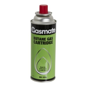
Fuel canisters used in single burner butane stoves contain a compressed blend of butane and propane. Butane typically accounts for 70 to 80 percent of the fuel mixture – with propane making up the remainder.

butane stove


How it works

The pressure in the canister keeps most of the mixture in a liquid state although a small amount vaporises into a gas above the liquid. When the canister is attached to a stove and turned on, the gas is forced out of the canister to the stove burner.

In order for this to work, the pressure inside the canister must be greater than the pressure outside.

Cold weather performance

However, as the canister temperature drops below freezing, its internal pressure starts to drop until this is no longer the case and the burner sputters and goes out.

This is because butane stops vaporising at 0.5 degrees Celsius (its boiling point).

Unlike butane, however, propane continues vaporising even in very cold temperatures (down to minus 42 degrees Celsius). This has some interesting implications for cold weather performance.

butane canister

Propane burns off at a disproportionate rate in temperatures below freezing. As the remaining butane/propane mixture shifts increasingly toward just butane, less and less fuel vaporises until eventually the pressure in the canister drops below what is required to continue feeding the stove. This means that a brand new fuel canister may work for a while in sub-freezing conditions, but can stop working long before the canister is empty.

Other factors

There’s also another factor that affects a butane canister’s cold weather performance. The process of vaporisation—the changing of physical state from liquid to gas—takes energy. In a butane canister, that energy comes mostly from the latent heat in the fuel mixture itself, which is why a fuel canister will become noticeably cooler while the stove is operating. In cold temperatures, this effect can drive the canister temperature down and stop the burner cold—even if the ambient temperature is above the butane’s boiling point.

Driving on the Beach

Here are some tips for when you are on one of Western Australia’s 2051 mainland beaches along its 12,889 kilometre coastline:

Have permission/check signage to ensure you are allowed to drive on the beach.
Check tides.
Is your vehicle insured when driving on a beach or sand dunes?
Road rules apply. Stay left when approaching traffic.
Don’t block tracks when deflating or reinflating tyres.

Fit a bright coloured flag on a tall pole at the front of your vehicle.
Have the right equipment for you and your vehicle.
Protect from glare. Wear sunglasses – preferably Polaroids.
Ensure that your rego plate is secured top and bottom, particularly if going through water.
Don’t follow too close to the vehicle in front.

Turn off any traction or stability controls.
Lower tyre pressure to increase footprint.
Be aware that you will use more fuel.

Be aware of the beach conditions.
Don’t drive on vegetation.
Watch your water temp gauge/EGT gauge/transmission temp gauge.

Drive up the beach to turn around.
Park facing the water – so you can observe any changes in conditions.

Don’t turn sharply. Tyres with reduced pressure could roll off the rim.

Don’t brake. Roll to a stop.
Don’t spin your wheels.
Take off slowly.
Maintain momentum.
As a general rule use low range.  High range if the surface is firm.
If bogged try going backwards and forwards.
Keep revs high. This applies for most circumstance but it is pointless to spin your wheels if bogged.

Keep your thumbs pointing out from the steering wheel.
Use correct recovery techniques and safety precautions.
Secure your gear afterwards/check you have it all (sometimes MaxxTrax get buried, shackles get dropped into soft sand).

Straight up or straight down a dune – never at an angle.
Never turn on a dune/slope.
Pause/brake/slow down at the top of dunes.

Wash your vehicle underneath after you are off the beach.


© Kim Epton 2017-2024
345 words

Feel free to use any part of this document but please do the right thing and give attribution to adventures.net.au. It will enhance the SEO of your website/blog and Adventures.

See Terms of Use.

Ballinyoo Bridge

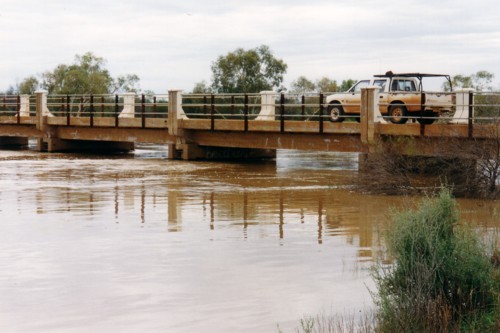
Ballinyoo Bridge is 80 kilometres south of the Murchison Settlement on the Carnarvon Mullewa Road. Construction started in 1929 and the bridge was completed in 1930. It was the second concrete bridge to be built in Western Australia and, until replaced, it was the oldest concrete bridge in WA. (Bridge No. 837).

A free camping area extends along both banks of the Murchison River just off the Carnarvon Mullewa Road. Bush camp are available on both sides of the road and on both banks, although the north side is probably preferred. Please take all your rubbish with you when you leave.

The opening of a new, longer, higher, parallel, $5.5M bridge built by BG&E Engineering of Perth was celebrated by a long table lunch on 10 September 2016. A span of the original cement bridge was retained to commemorate its place in the history of the community.

Early drovers crossed the Murchison at Ballinue, however, when surveyor Harry F. Johnston was operating in the area in 1876 he recorded the name as Ballinyoo. The importance of this crossing continued after construction of the concrete bridge and this was an important factor in consideration of its replacement.

The bridge was a focal point on a number of pioneering boating expeditions along the Murchison River in the 1990s.

Early drovers crossed the Murchison at Ballinue2, however, when surveyor Harry F. Johnston was operating in the area in 1876 he recorded the name as Ballinyoo3.

References

1. Main Roads Department (Bridge No. 837).
2. Broad, Nan with Bridge, Peter (eds), The Journal of the Brockman Droving Expedition of 1874−75 to the North West of Western Australia, Hesperian Press, Carlisle, Western Australia, 2006.
3. H.F. Johnston, Fieldbook 3, page 37.


The reports of the various trips, tours and travels on the Adventures website have a lot of information about place names – their naming and features – toponymy. More information.

© Kim Epton 2015-2024
339 words, one photographs.

Feel free to use any part of this document but please do the right thing and give attribution to adventures.net.au. It will enhance the SEO of your website/blog and Adventures.

See Terms of Use.