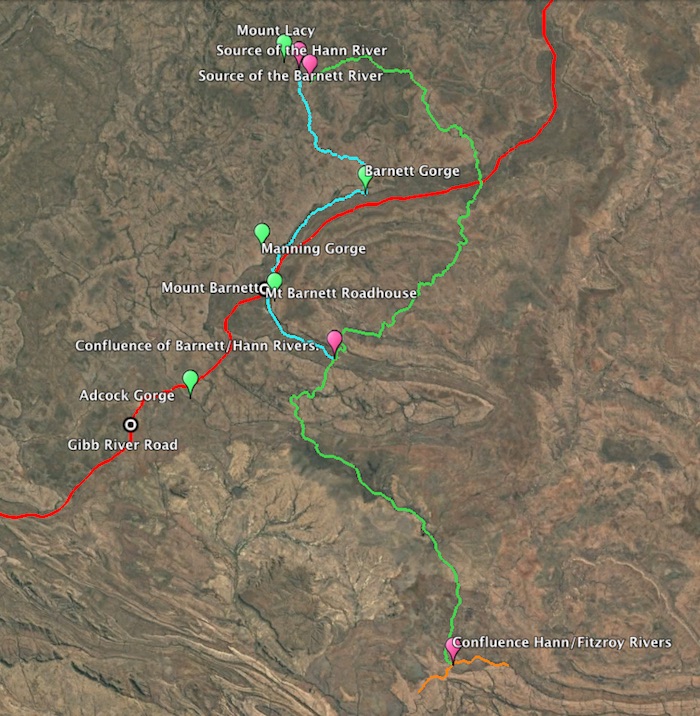
- Hann River and surrounding rivers and gorges.
Course of the River
The Hann River rises below Mount Lacy and Sir John Gorge at 16°19’ 30”S 126° 0’ 53E” and flows generally south-east for about 224 kilometres into the Fitzroy River.
Naming of the River
The indefatigable explorer Frank Hann named this stream the Phillips River on 20 July 1898,
“The river from the north north west falling into Fitzroy, which I have just discovered, I called the Phillips, in recognition of the assistance afforded to me by the Commissioner of Police, and for which my best thanks are due.”
However, it was Robert Button, and not Hann, who discovered the river, as Hann himself records,
“At the point where I struck the river I found a tree marked RB44 by Mr Robert Button, the 44 standing for the 44th camp.”
The marked tree referred to by Hann was at the junction of a stream that he appropriately named Button Creek.
Button did not record when he discovered the river however it was possibly 1897.
However, regardless of the name originally applied and seemingly without regard to its discoverer, the stream was shown on public plans in 1900 as the Hann River.
Hann’s original name for the river was not retained because it duplicated that of the Phillips River near Ravensthorpe (named after Samuel Pole Phillips in1848 by the then Surveyor General, J.S. Roe).
Frank Hann
Frank Hugh Hann (1846-1921) was involved in the cattle industry in the Gulf country until 1896 when he travelled to Western Australia, exploring the Nullagine district and searching for gold at Mt Broome. In 1898 he penetrated the King Leopold Ranges that had been a barrier to exploration for more than two decades. His perseverance gave all others access to the hinterland of the Kimberley.
Hann explored over a greater proportion of Western Australia than anyone else. He was active in the Great Victoria Desert, the south-east and the south-west of Western Australia. He named more than 500 geographical features across the length and breadth of the State – in fact, far more than any other person. Consequently he had a large number of features named after him in all parts of the State.
Some of these are the Hann Breakaways in the Great Victoria Desert, and Mount Hann near the head of the Prince Regent River.
Other features to be named in his honour include Hanns Camp near Laverton, Hann Pass through the King Leopold Ranges, Hann Rockhole, Hanns Table Top Hill south of Warburton, Hanns Jasper Hill on the edge of Lake Minigwal in the Great Victoria Desert and the Frank Hann National Park east of Lake King.
Hann continued his explorations throughout Western Australia until 1908. He died unmarried in Perth.
Hann’s diaries were accurately reproduced in Do Not Yield To Despair edited by Mike Donaldson and Ian Elliot, and published by Hesperian Press in 1998.
Travellers on the Gibb River Road cross the Hann River south of Mt Elizabeth about 15 kilometres west of Gibb River station homestead.
| LENGTH 224 kilometres SOURCE Mt Lacy, Caroline Ranges (220 kilometres north north-east of Fitzroy Crossing) SOURCE (AMG) 180999 metres East 8192777 metres North FLOWS INTO Fitzroy River ENDPLACE Narrie Range (115 kilometres north-east of Fitzroy Crossing) MOUTH (AMG) 213000 metres East 8070000 metres North TRIBUTARIES Hann North River, Barnett River, Traine River, numerous named and un-named creeks 1:100,000 MAPS Jameson 4065, Gibb 4165, Barnett 4164, Packhorse Range 4064, Mount House 4063, Glenroy 4163 1:250,000 MAPS Mt Elizabeth SE 52-1, Charnley SE 51-4, Lennard River SE 51-8, Lansdowne SE 52-5 |
REFERENCE:
Epton, Kim, Rivers of the Kimberley, Hesperian Press, 2000.
Read about other rivers in Western Australia and Australia.
© Kim Epton 2022-2025
617 words, one image.
Feel free to use any part of this document but please do the right thing and give attribution to adventures.net.au. It will enhance the SEO of your website/blog and Adventures.
See Terms of Use.

