The Murchison River is Western Australia’s second longest. From its headwaters it flows 835 kilometres through pastoral country and the spectacular Murchison Gorges to its mouth at Kalbarri.
The annual rainfall in the Murchison region is only 250 mm. Compare this with Perth’s average of about 730 mm. The catchment is about 80,000 square kilometres (about the size of Austria).
The flow of the Murchison River (about 200 million cubic metres per second (cusecs) per year) varies greatly – for instance in 1975 it was 820 million cusecs, more than four times the average.
This annual flow compares with a figure of :
* 320 million cusecs for the Avon/Swan River (on which Western Australia’s capital city, Perth, is situated),
* 660 million cusecs for the Blackwood (the biggest river in W.A.’s south-west),
* and 12,500 million cusecs for the Ord River (greatest flow of any river in Australia).
The Murchison is a pastoral area. Its significance insofar as its income versus its cost to the environment is debatable. This is increasingly obvious as the Department of Parks and Wildlife (DPaWs) buys up ‘ecosystems’ in the regions and reverts to them to pre-settlement conditions. Mining and tourism are becoming increasingly important.
European Discovery of the Murchison River
Lieutenant George Grey discovered the mouth of the Murchison River on 1 April 1839 during his return from an exploration of the Shark Bay area. His boats were wrecked the previous day when an attempt was made to beach them at Gantheaume Bay.
-

- George Grey
Grey and his party walked to Perth, a 500 kilometre trek to the south.
Naming of the Murchison River
Grey named the river after Sir Roderick Impey Murchison, a noted geologist who was elected President of the Royal Geographical Society in 1831.
-

- Sir Roderick Impey Murchison (1792-1871), Scottish geologist
The Roderick River and the Impey River are tributaries of the Murchison thus making Sir Roderick the only person after whom three rivers in Western Australia are named.
Background to locating the Source of the Murchison River
Between 1994 to 2020 I led a loose grouping of power dinghy racing enthusiasts on seven trips on the Murchison River.
First Murchison River Expedition 1994
From Milly Milly Crossing to Galena Bridge.
No Wimps Allowed 1995
Through the spectacular Kalbarri Gorges.
Flood Mid and Boats 1997
The third expedition on the Murchison River started from Murchison Crossing.
Murchison River Expedition 2004
From Milly Milly Crossing 525 kilometres from the river mouth at Kalbarri through to Billabalong Station.
Murchison River Expedition 2006
From Yallalong to Galena Bridge (North West Coastal Highway).
Murchison River Tour 2006
From Milly Milly to Billabalong.
Murchison River Expedition 2020
Furthest upriver ever – 556 km from the mouth.
Background
Most of the flows in the Murchison result from tropical cyclones crossing the coast and bringing rains to the region. Read more about tropical cyclones as they relate to Murchison rainfall.
As we made more and more trips to the Murchison the obvious question was asked, “Why don’t we tackle the river from its source?”
This brought up a number of questions, of which two were fairly obvious:
1. Where is the source?
2. Can we get boats downriver from there?
It became clear that even after we had determined the source we were not going to be able to boat down the river – when there was sufficient water in the river to float a boat the roads were impassable and closed by the local authorities.
During the time we were boating the Murchison there were a number of occasions when the greater part of the river was flowing – possibly as far up as Bilyuin. And it was of ‘boatable’ depth.
But there was a problem of vehicle access. Water in the river in that part of the country meant closed roads. And our resources didn’t extend to helicopters.
Byro-Beringarra Road Crossing, from where a number of our expeditions started, is about 200 kilometres north of Murchison Roadhouse and about 530 kilometres upriver from the mouth at Kalbarri. At the time of the 2006 expedition the river at Byro-Beringarra Road Crossing was seven kilometres wide. By 2006 we knew more about the river than even the locals. Our direct, on-the-ground, on-the-river knowledge of the Murchison extended from Milly Milly to the coast.
Given the conundrum of high water levels and closed roads, after the 2020 Murchison River Expedition, Mt Gould Road Crossing, 576 kilometers upriver from the mouth, will remain as the furthest point inland from where the river has been navigated. And it is my view that it would take a remarkable set of circumstances and an extremely well prepared group to change that fact. The full, feasibly-navigable length of the Murchison River has been ‘boated’.
As upriver, on-river travel was problematic I switched my focus to land-based investigation.
The Source of the Murchison River
There is much poorly researched material that states the source to be at Bilyuin Pool (90 kkilometres north-west of Meekatharra, about 750 kilometres from the mouth). And yet the river length is quoted as being 835 kilometres.
A cursory glance at maps will show that Bilyuin cannot be the source of the river. A classic case of the printed word being accepted as fact, regardless of ‘due diligence’, and being reprinted over and again. Once something gets into print it acquires an imprimatur of authority.
So, I determined that Bilyuin was not the source of the Murchison River.
I checked with the Manager of Doolgunna Station, north of Meekatharra. He assured me that the source of the Murchison River was the overflow from the Station Homestead tank. I thanked him for his input and continued my research.
From maps and information from station managers, I determined that the start of the Murchison River is at:
Central Bore near St Crispin Mine on Doolgunna Station at the eastern end of the Robinson Range, 100 kilometres NNE of Meekatharra.
-
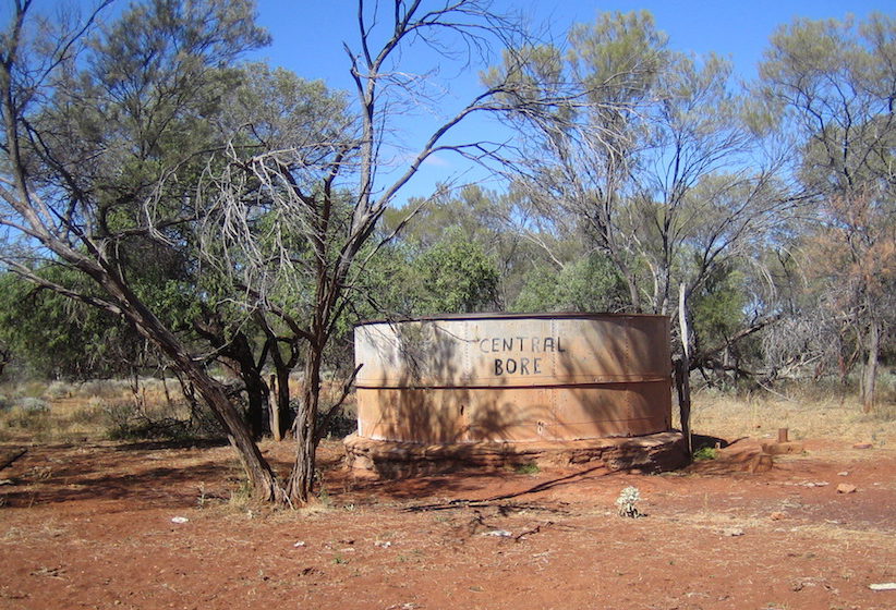
- Central Bore.
Rangeland managers past and present to whom I addressed the question of the source of the river have suggested that a case could be made for the river’s source to be past Lake Annean. The Hope/Yalgar flows through Lake Annean and joins the Murchison at Moorarie, via the Ord, 140 kilometres from the source. In times of flood more water flows down the Hope/Yalgar River than the length of the Murchison upriver from the confluence of the two. If this is indeed the true hydrological course of the Murchison then it would be Western Australia’s longest river.
The precise source of the Murchison River is:
UTM 50J 0710637mE 7164643mN
Degrees Lat Long -25.6207837°, 119.0977497°
Degrees Minutes -25°37.24702′, 119°05.86498′
Degrees Minutes Seconds -25°37’14.8212″, 119°05’51.8989″
First Land Based Investigation 2006
Murchison Source Expedition 2007
Murchison Source Expedition 2008
© Kim Epton 2015-2025
1109 words, three photographs.
Feel free to use any part of this document but please do the right thing and give attribution to adventures.net.au. It will enhance the SEO of your website/blog and Adventures.
See Terms of Use.