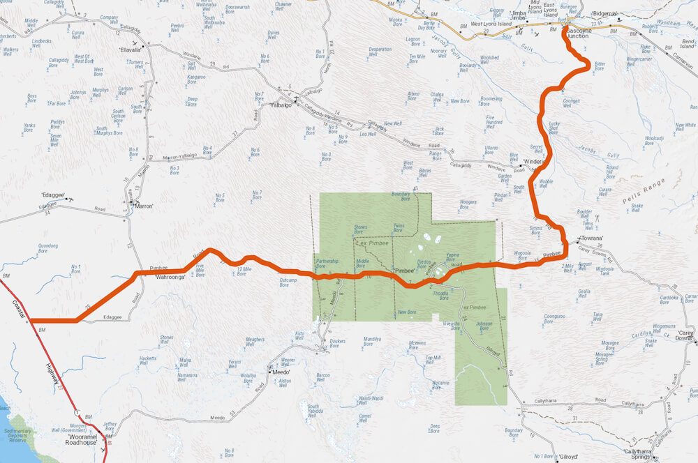
The last time I drove this track was in August 2018. There was not a cloud in the sky, no heat haze and I could see a long way in front. Perfect driving conditions.
The track leaves the North West Coastal Highway 26 kilometres north of Wooramel Roadhouse at 25° 34’ 32”S 114° 09’ 37”E. It is a big, wide, open road with lots of bends and numerous grids.
- Alternative Route to Gascoyne Junction
The ‘Alternative’ refers to not having to go to Carnarvon – a saving of 94 kilometres.
Vegetation along the Route is scrubby and scraggly, typical of the Gascoyne. Mostly acacias with a few eucalypts on the dunes.
The track has wide, sweeping bends. The chances of oncoming traffic are very slight but not nil. You need to be on the correct side of the road. In this part of the world a crash with a combined speed of 180-240 kph is not going to end well. Even if you did survive the crash you are a long way from any help. Stay wide on bends.
Closer to Gascoyne Junction the track heads north over longitudinal, vegetated dunes and is mostly aligned in the swale of these dunes. The ‘Crest’ referred to on the numerous warning signs are actually the top of the dunes. Nearing Gascoyne Junction the track curves around to the west rather than go over the top of the dunes. This alignment of the road would be from pre-motorised vehicle days when it was easier to go around the dune than over it.
There are a few inconsequential dips at the Gascoyne Junction end of the track. Depending on when the grader has been through it is an easy drive. It is red dirt across the plains and gravelly closer to Gascoyne Junction.
There is a gate at Gascoyne Junction allowing the track to be closed when it is impassable.
24 hour fuel is available via credit card at Gascoyne Junction.
Fuel is available at Wooramel Roadhouse during business hours.
Grid 1- is of no concern.
Grid 2 – same.
Grid 3 – the recommend speed is 40 kph. Can be negotiated at 80 kph.
Grid 4 – is bit rougher but ok.
Grid 5 – is ok.
Grid 6 – is good.
Grid 7- is easy.
Grid 8 -either side is rough.
For details of other, lesser-known tracks, go to the Wells and Tracks website.
Download the GPX File for this track.
© Kim Epton 2018-2024
423 words, one image.
Feel free to use any part of this document but please do the right thing and give attribution to adventures.net.au. It will enhance the SEO of your website/blog and Adventures.
See Terms of Use.

