Lake Raeside is Australia’s longest lake – by a large margin.
The lake was named after W.J. Raeside a government engineer responsible for putting down bores on the goldfields in the 1890s.
The name for the lake was recorded by Surveyor G.C. Hamilton in 1895 and then by Surveyor G.D. Robinson who traversed it in 1897.
Lake Raeside is a salina – a salt lake or salt flat. A salina is essentially a body of water with a high concentration of salts. The term comes from the Spanish/Latin word for ‘salt’.
It forms part of a larger drainage system of lakes that are located in regionally extensive valley floors. This system includes Lakes Moore and Barlee, situated in the west and draining to the east and southeast. The drainage system is subject to extensive regional flooding during intense storm events, such as experienced during and after Cyclone Bobby in February 1995, flowing down Ponton Creek to Lake Boonderoo.
It is stated on the Shire of Leonora’s Facebook page that:
“Lake Raeside is part of a larger lake system that begins north of Leonora near Sir Samuel at Lake Miranda and extends south east to Lake Goddard – a distance of over 800km.”
This is totally erroneous – there is no Lake Goddard in Western Australia. 800km south-east of Lenora is 120+ km into the Southern Ocean.
The Post on the Shire’s Facebook page continues more factually – “The lake is generally dry, covered with a thin film of salt. During extreme rainfall the lake can be transformed into a flowing waterway and take on the dynamic characteristics of a real river.”
Lake Raeside’s origin is north-west of Leonora on the boundary of the Shire of Leonora and Shire of Menzies at 28°43‘ 120°38‘.
-
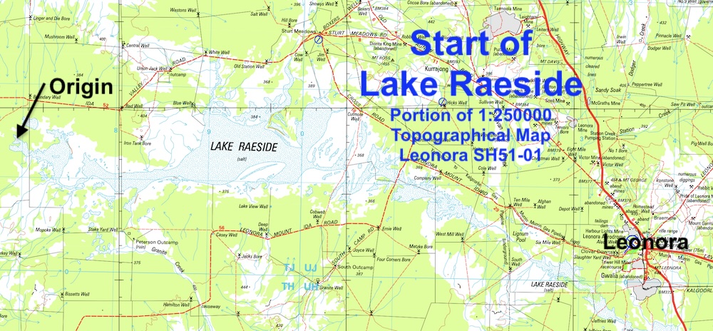
- START OF LAKE RAESIDE.
It then extends south-east to where it discharges into Ponton Creek at 29°28‘ 121°52‘, a distance of 274 kilometres.
Waigen Lakes is not Lake Raeside – Google Earth
Waigen Lakes are erroneously shown on Google Earth as being north-west of Leonora, whereas it is actually the start of Lake Raeside. Waigen Lakes are actually 750 kilometres east-north-east of Leonora.
Australites at Lake Raeside
Lake Raeside is known for Australites – the Australian name for tektites. The Western Australian Museum has over 900 examples from the area.
Most scientists believe Australites were formed after a large asteroid or comet struck Indochina, 800,000 years ago. This flung material up, and in the case of the rock that landed in Australia, just out of the atmosphere, forming unique shapes as they melted when re-entering. These Australites form a vast strewn field at 25 degrees latitude (approximately) across southern Australia. Most Australites are found in remote South Australia and Western Australia, due to the lack of tectonic upheavals.
Australites can be various shapes including sphere, oval, boat, discs and dumbbell. The most collectible are undamaged flanged button shapes.
Route and Measurement of Lake Raeside
Download GPX file of Lake Raeside Length – 274 km
Detailed measurement of the length of Lake Raeside
Other Long Lakes in Australia
Lake Eyre 205 km
Lake Amadeus 180 km
Kumpupintil Lake/Lake Disappointment 160 km
Lake Carnegie 100 km
Lake Mackay (also known as Wilkinkarra} 100km
Lake Frome 100km
Lake McLeod 65 km
Lake Torrens 65 km
Lake Cowan
Lake Lefroy
Lake Moore
References:
Geoscience Australia, 1:250,000 Topo Maps Leonora, Menzies, Edjudina, Kurnalpi.
W. G. Martinick & Associates Pty Ltd, “Kalgoorlie to Meekatharra Road … SLK 310, Kent Bore Quarry: Environmental Assessment and Management Plan”, 1996.
Lake Raeside, Mindat
© Kim Epton 2025
591 words, one image.
Feel free to use any part of this document but please do the right thing and give attribution to adventures.net.au. It will enhance the SEO of your website/blog and Adventures.
See Terms of Use.