Along the Beach from WA/SA Border
The track adjacent to Eucla Telegraph Station ruins leads to the beach. An easy drive. The plan was to find our way to the SA/WA Border along the beach.
This is Eucla Beach (WA Beach 1) that extends from the WA/SA Border and trends west-south-west for 41.5 kilometres. We started on the beach below the 100 metre high Wilson Bluff and followed it for its full length to Low Point.
- ROUTE OF WA/SA BORDER TO CAMP ON HEARDER HILL TRACK
The run east along the beach was easy for the first 1.6 kilometres, at which point we had to find an alternative track off the beach. After eight kilometres through the bottom of the Delisser Dunes we were able to return to the beach and make our way to the WA/SA Border – 1240 kilometres from Perth (direct line).
- At the border of Western Australia and South Australia.
Eucla Jetty
The drive west was along the beach back to point where we had earlier headed into the dunes. From a different perspective we were able to find a way through without leaving the beach.
Two kilometres further west is the remains of the Eucla Jetty. Another photo opportunity.
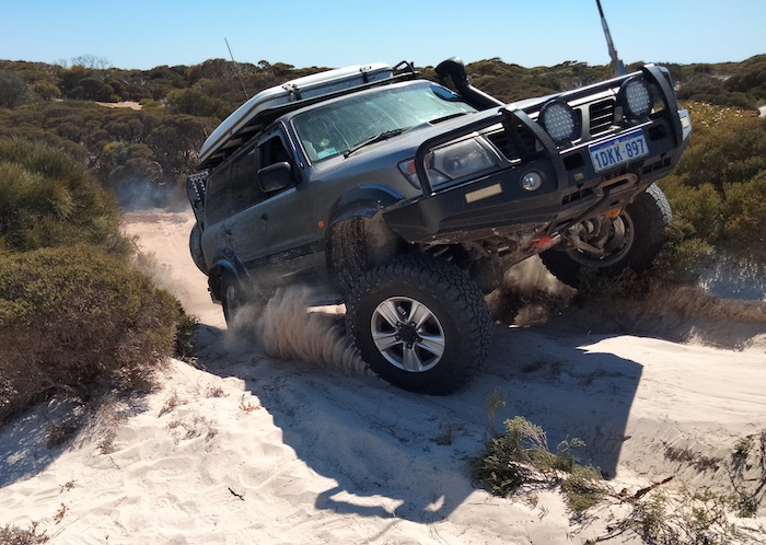
For the entire journey along the beaches Zeljko was ‘lead’ in his FJ Cruiser, scouting for a way. As is usually the case with the first vehicle, he got bogged more than most as he tested suitable routes. Goes with the job!
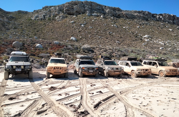
- Our convoy at the remains of the Eucla Jetty.
The beach was wide, open and firm. The tide was out.
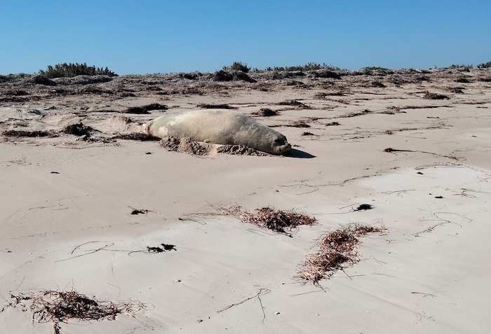
- Large sea lion taking a break.
- Basking sea lion.
The Beach is Blocked
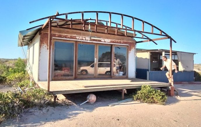
After an easy 24 kilometre run along the beach west of the jetty the good run finished. The way forward was blocked by rocks. We returned about 2.7 kilometres and found a way off the beach. The track paralleled the beach, just back from the foredunes. We came across a couple of squatters’ huts.
- Squatters/fishers hut.
- More elaborate, very remote holiday home.
About four kilometres along the track we found a way around the rocks and returned to the beach. Beach 1 transitioned to WA Beach 2 five kilometres after we exited the dunes onto the beach although the feature to mark this, Low Point, is indiscernible.
- Jo and Andrew checked out what initially appeared as an unusual sight that in actuality was just matted, probably dead, sea grass.
Hearder Hill Track
The good run west continued for 27 kilometres from WA Beach 2 to WA Beach 3. Six kilometres along WA Beach 3 we turned off to our selected campsite on what showed on our maps as Hearder Hill track.
- Seaweed covered beaches were common.
Four hundred metres off the beach we found a flat, open area out of the wind that was an excellent campsite. Hearder Hill itself was nowhere to be seen.
And so ended a successful day – all plans achieved.
Rocks Block Beach
We made our way from the campsite back to the beach (WA Beach 3), hoping to drive along it to Noonaeara Station homestead ruins, 49 kilometres to the west-south-west.
- ROUTE FROM CAMP ON HEARDER HILL TRACK TO ABOVE EYRE BIRD OBSERVATORY
In less than five kilometres of travel on the sand the way was blocked by rocks.
- Rocks blocking beach.
- Kim’s Patrol at the rocks.
We backtracked a hundred metres and tried for some time to find an inland way around the obstacle.
- Jo drives the Prado off the beach.
- Scott takes his Patrol off the beach.
- Gary in his Pajero.
After a considerable time searching for a way that would take us around the rocks and back to the beach it was clear that we would not be successful. There was no option but to return to the Hearder Hill track and try to find another way to Noonaera ruins.
- Gary returns his Pajero to the beach.
- Scott takes his highly modified Patrol back to the beach.
Track to Noonaera
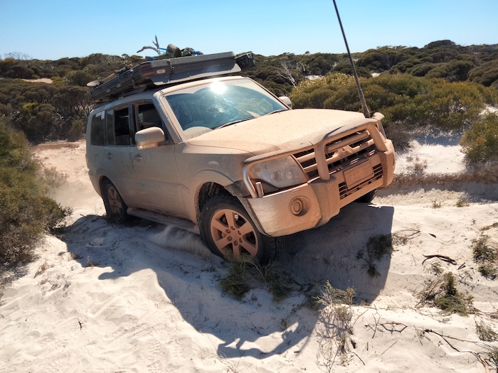
We stopped at our campsite of last night and aired up a bit. This was perhaps a bit early as we encountered a couple of long stretches of soft and loose sand not long after airing up. The loose sand extended for about a kilometre, causing several boggings but they were easily resolved.
Five kilometres north we came across a well-formed track that we were confident would lead us to Noonaera ruins. Left turn.
Starling Traps
At intervals along the track there are a number of well-constructed starling traps. These birds are a threat to Western Australia agriculture, particularly horticulture. Starlings are not endemic to WA and, to date, they have been kept under control. The traps placed along the Roe Plains and other parts of the Nullarbor Plain are just one part of the official prevention strategy. The starling is a declared pest in WA.
- A starling trap is located at the end of this short deviation from the main track.
This a very remote area and operation/maintenance of these traps would be difficult and expensive. Staff at Eyre Bird Observatory monitor traps closer to their location but not these traps.
The track crosses an extensive depression that clearly many years ago was a salt lake and, given sufficient rainfall, may still hold water. It was on this vegetated depression we sighted an Australian Bustard.
- Old saltlake.
- An Australian Bustard take flight.
Fourteen kilometres along the track we noticed a large building about a kilometre to the south. This structure is associated with a seasonal crayfishing camp. It is a further two kilometres to WA Beach 4 where crayfishermen would leave their dinghies – with their larger boats moored offshore.
There are numerous starling traps along this track.
- Starling trap.
Noonaera Ruins
The track we had been following for 50 kilometres took us to the Noonaera ruins.
- Noonaera Rockhole was modified and improved to reduce evaporation.
- The ruins of Noonaera Station homestead..
Thick, overgrown vegetation prevented access to Noonaera Beach (WA Beach 6). Time spent with an axe or chainsaw (such time we didn’t have) would resolve the issue.
There was no possibility of continuing westward on the beach through to Kanidal Beach at Eyre Bird Observatory. Our only option was to ‘cut and run’ to EBO via an alternative route.
Exit to Eyre Highway
After a good look around the ruins we exited towards Eyre Highway. Gary led the way across the Roe Plains towards the very visible Hampton Tableland and found an ideal spot to air up at the entrance to Mundrabilla Station. It was hot – about 40 degrees Celsius.
After 80 kilometres heading west on the bitumen, we drove up the Madura Pass and turned right opposite to the entry to the Roadhouse to ascend the old Madura Pass. The track along the top of the Hampton Tableland provides great views over the Roe Plains.
- View across the Roe Plain from the Hampton Tableland at Madura.
Madura Cave
We returned to the Eyre Highway, descended the current day Madura Pass and turned south onto the track that leads to the Madura Cave and then Madura Beach.
After visiting the easily accessible Madura Cave we headed towards Burnabbie with some trepidation among the convoy that we may not be taking the correct track. The dog fence track was in good condition and dead straight for 14 kilometres, providing an ideal connection to the Burnabbie track.
Tree Across Track
The light was fading fast and the selected overnight stop, Lineman Camp, was deemed unsuitable. It was crap – sloping, uneven and no cleared areas.
- Moonrise at Lineman Camp.
We pushed on towards Burnabbie. Only metres before this pioneer homestead a large tree blocked the track. The chainsaws were put to work.
- A larege tree blocked our way.
Above Eyre Bird Observatory
With the downed tree cleared we had access to Burnabbie but the lack of light and thick dust (no breeze) meant that we crossed that location off our list of places to camp.
After a few minutes of radio chatter we sorted out our geographical embarrassment and headed to the parking area above EBO (on top of the Hampton Scarp) that we believed would make a suitable camp.
It was tight but there was enough room for everyone for the night.
- EYRE BIRD OBSERVATORY TO TWILIGHT COVE AND RETURN
In the morning a radio call to EBO assured us that they were ‘open’ and we could proceed down the Scarp and along the track 10 kilometres to the Observatory.
- Folding the change shelter is always a challenge.
Eyre Bird Observatory
- Andrew at Eyre Bird Observatory
The old telegraph station at Eyre is used as an observatory by Birds Australia and is staffed year round. The building also houses a small but interesting telegraphic museum. The observatory is about one kilometre off the beach in Australia’s largest single sand dune system (note spurious claims by various 4WD websites that Bilbunya Dunes, Yeagarup Dunes or even Stockton Bight is the largest).
Kanidal Beach
After a pleasant and informative tour of EBO we headed for Twilight Cove via Kanidal Beach (WA Beach 13).
- Preparing to snatch out Zeljko’s FJ after getting bogged in soft seaweed/sand. Zeljko was ‘scouting’ the way ahead and getting bogges was inevitable.
- Kim preparing to snatch out Zeljko’s FJ Cruiser.
Kanidal Beach was a challenge. Many soft spots and lots of seaweed. We eventually reached the inland track that would take us to Twilight Cove (WA Beach 16).
Twilight Cove
Twilight Cove is one of only two safely accessible places on the south coast between Israelite Bay and Fowlers Bay – a distance of over 900 kilometres.
When the telegraph line was built in 1875-77 nearly all equipment was transported by sea and then carted to the line of route. Lack of access along the length of the Baxter Cliffs made the job of getting poles and equipment to the line of route difficult. Twilight Cove, along with Toolinna Cove to the west, was the only spot along the cliffs to offload this materiel.
Beach Boggings
It was determined that the track to Cocklebiddy would be too slow so we headed back to EBO to take that better track out to the Eyre Highway.
The return was not without difficulties. Seaweed (as usual) was the problem.
- Just one of the numerous boggings on the return from Twilight Cove.
Getting off the beach was not easy.
- Andrew attaches snatch strap to Prado.
That part of Drive the Coast was finished.
We headed out to the Eyre Highway to push westward as far as we could while there was good light for driving.
Check out Gary’s great video of the full trip.
© Kim Epton 2023-2024
1790 words, 34 photographs, 3 images.
Feel free to use any part of this document but please do the right thing and give attribution to adventures.net.au. It will enhance the SEO of your website/blog and Adventures.
See Terms of Use.


