Departing Peak Charles
We departed Peak Charles through Annes Pass and along Dunn Track (actually an old shotline) looking for the obscure track to Lake Sharp. Special care is needed at the five way junction 10 kilometres south of Peak Charles to ensure the correct track is selected.
Lake Sharpe Track
The turnoff to Lake Sharpe is difficult to see, being partly overgrown, and I needed to travel along it for a few hundred metres to confirm we were on the correct route. Just over two kilometres in, the margin of the lake appeared. Saltbush and bluebush country. The track follows the edge of the lake for 14 kilometres. Classic outback Australia.
-

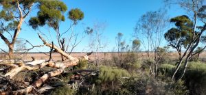
- Peak Charles from Lake Sharpe.
-

- Track through Lake Sharpe.
In a number of places the track was difficult to follow and it needed a bit of investigation on foot to find the way forward.
-

- Jo and Andrew on the Lake Sharpe Track.
-

- Track along the edge of Lake Sharpe.
-

- Graham in his Prado negotiating the track along the edge of Lake Sharpe.
As the track leaves the lake it merges with a recently made two blade firebreak/containment line. Closer to the Lake King Road it narrows to one blade width. The uncertainty of following this firebreak increased when it made a diversion to the east. After a kilometre it again, reassuringly, turned north towards the Lake King Road.
North of the lake much of the country has been burnt out and we surmised that it was to combat this fire that the firebreak/containment line had been made. Our convoy of vehicles was very clearly the first to travel this track since it had been made – probably by a loader. In some places it disappeared or was very difficult to follow.
-

- The fire had stripped out huge swathes of the country, however, there was evidence that the bush was coming back.
-

- The firebreak/containment line became difficult to see on occasions.
Surveyor T.A. Ellison named Lake Sharpe in 1929 while doing ‘classification surveying’ but he failed to record after whom he named it.
After a couple of Y junctions where we guessed at the direction to take we came out onto the Lake King-Norseman Road.
-

- On the Lake King-Norseman Road after exiting the Lake Sharp Track.
-

- LAKE SHARPE TRACK
Lake Hope Track
After 20 kilometres of westward travel we turned north onto the Lake Hope Track and a short time later stopped for lunch under a solitary stand of trees.
-

- Lake Hope.
-
- There were many large fallen trees along the edge of the lake, possibly the result of a storm.
-

- The track followed the margin of the lake.
-

- LAKE HOPE TRACK
This remote track leads through the Bremer Range, along the Honman Ridge and past Lake Hope to the Maggie Hayes mine on the Hyden-Norseman Road. There are numerous shotlines crossing the track along its length.
-

- Shotlines on the Lake Hope Track.
-

- Nearly dry Lake Hope.
-

- Nearly dry Lake Hope.
Lake Hope was named by explorer Frank Hann in 1901 after Joseph Hope, Chief Draftsman of the Lands and Surveys Department, 1896 to 1919.
The Breakaways
We turned on to Hyden Norseman Road and I started to look for a suitable campsite – and 23 kilometres to the west we turned into The Breakaways. As per usual we collected firewood just before arrival.
-

- Firewood delivery at The Breakaway campsite.
-

- Our campfire at The Breakaways.
Hyden
Hyden was an opportunity to refuel and regroup after a stoppage for a mechanical/electrical issue.
Mulkas Cave
Mulkas Cave (previously known as Bates Cave, after an early sandalwood cutter) is one of the most significant rock art sites in Western Australia. A total of 452 motifs have been recorded in the three chambers. Most other sites in the South West have fewer than 20. This is a clear indication of the significance of this site.
-

- Outside Mulkas Cave.
-

- Inside Mulkas Cave.
The Best for Last
From Mulkas Cave we headed west on Billericay Road – into the rain preceding Tropical Cyclone Seroja. As we progressed westwards the roads got steadily worse. Slip Sliding Around! Scott and Howezit had left us by this time – taking a more northerly course home.
It was time to head for the bitumen. We headed across Lake Kurren Kutten to get to sealed Bendering Road. Like ballet – but no control! Two kilometres later we all reached the bitumen without sliding off the road. Phew!
-

- Crossing the southern portion of Lake Kurren Kutten to get to Bendering Road.
The Road Trip finished at Corrigin.
© Kim Epton 2021-2024
788 words, 18 photographs, three images.
Photographs
Kim Epton
Lone Neilsen
Graham ‘Howezit’ Howe
Feel free to use any part of this document but please do the right thing and give attribution to adventures.net.au. It will enhance the SEO of your website/blog and Adventures.
See Terms of Use.