The Murchison River is considered to be Western Australia second longest.
Since 1994 when our group of boating enthusiasts first put a boat on the water at Milly Milly Crossing, 525 kilometres upriver from Kalbarri, the holiday town at the river’s mouth, I was interested in determining the source.
-

- Kalbarri – at the mouth of the river.
River Trips
Between 1994 to 2020 our group of power dinghy racing enthusiasts made seven trips on the Murchison River.
First Murchison River Expedition 1994
From Milly Milly Crossing to Galena Bridge.
No Wimps Allowed 1995
Through the spectacular Kalbarri Gorges.
Flood Mid and Boats 1997
The third expedition on the Murchison River started from Murchison Crossing.
Murchison River Expedition 2004
From Milly Milly Crossing 525 kilometres from the river mouth at Kalbarri through to Billabalong Station.
Murchison River Expedition 2006
From Yallalong to Galena Bridge (North West Coastal Highway).
Murchison River Tour 2006
From Milly Milly to Billabalong.
Murchison River Expedition 2020
An expedition from 556 kilometres inland, marking a new high start point.
Source of the River
As we made more and more trips along the river the obvious question was asked, “Why don’t we tackle the river from its source?” So where is the source?
-

- The Entry to Hardabut Rapid.
There is much poorly researched material that states the source to be at Bilyuin Pool (90 kilometres north-west of Meekatharra, about 750 kilometres from the mouth). And yet longer lengths for the river are variously quoted.
A cursory glance at maps will show that Bilyuin cannot be the source of the river. A classic case of the printed word being accepted as fact, regardless of ‘due diligence’, and being reprinted over and again. Once something gets into print it acquires an imprimatur of authority.
It is clear that Bilyuin is not the source of the Murchison River.
I checked with the Manager of Doolgunna Station, north of Meekatharra. He assured me that the source of the Murchison River was the overflow from the Station Homestead tank. I thanked him for his input and continued my research.
Checking further with station managers and looking at various maps, I determined that the start of the Murchison River is at Central Bore near St Crispin Mine on Doolgunna Station at the eastern end of the Robinson Range, 100 kilometres NNE of Meekatharra.
-
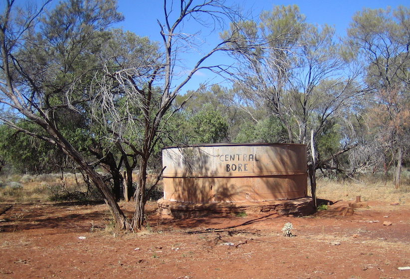
- Central Bore.
This determination needed to be confirmed ‘on the ground’. With others, I made three trips to Doolgunna to do this.
After the 2008 trip we were able to confidently state that the precise source of the watercourse named the Murchison River is:
UTM 50J 0710637mE 7164643mN
Degrees Lat Long -25.6207837°, 119.0977497°
Degrees Minutes -25°37.24702′, 119°05.86498′
Degrees Minutes Seconds -25°37’14.8212″, 119°05’51.8989″
This means the length of the Murchison River is 835 kilometres.
A Different Course for the River
Normally, that is where the matter would end. The Murchison is WA’s second longest river after the 865 kilometre long Gascoyne.
However, rangeland managers past and present to whom I addressed the question of the source of the river have suggested that a case could be made for the river to have a different source – past Lake Annean.
The Hope/Yalgar River flows through Lake Annean and joins the Murchison at Moorarie, via the Ord, 201 kilometres from its source. In times of flood more water flows down the Hope/Yalgar River than the length of the Murchison upriver from the confluence of the two – hence the contention the true hydrological course of ‘the Murchison’ is before Lake Annean – actually 13 kilometres east of Meekatharra and 44 kilometres north-east of the lake.
Crunch the numbers and you will see it that even with this amended course, it is still shorter than the Gascoyne.
© Kim Epton 2021-2024
638 words, three photographs.
Feel free to use any part of this document but please do the right thing and give attribution to adventures.net.au. It will enhance the SEO of your website/blog and Adventures.
See Terms of Use.