-
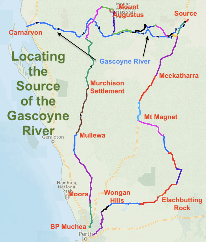
- MAP OF ROUTE – Locating the Source of the Gascoyne River.
Aim of the Road Trip
To use public roads to follow the Gascoyne upriver from Yinnietharra on the Dairy Creek Road (about 340km from the mouth/510km from the source) to where Western Australia’s longest watercourse rises.
To accurately determine the source of the river.
Along the way, visit a number of Western Australia’s iconic geographic locations including Mount Augustus, Lake Barlee, Elachbutting Rock and numerous other lesser-known points of interest.
The Gascoyne River
The Gascoyne River flows generally westward 850 kilometres from near Kumarina Roadhouse on the Great Northern Highway to the Indian Ocean at Carnarvon.
It was named by Lieutenant George Grey in 1839 after his friend Captain John Gascoyne RN.
The Gascoyne River is Western Australia’s longest river and the 10th longest river in Australia.
Joining Information
Dates
Friday 15 May 2026 to Thursday 21 May 2026 inclusive.
Area
Mid West
Murchison
Gascoyne
North-east Wheatbelt
Great Western Woodlands
Accommodation
Fri – Koojan – no facilities
Sat – Murchison Oasis – caravan park
Sun – Mount Augustus Caravan Park
Mon – Kumarina – bush camp
Tue – Mount Magnet – caravan park
Wed – Mt Marshall – bush camp
Thu – Home
Meeting Place
The Meeting Place is the BP Servo at Muchea Industrial Area.
Departure Time
Departure Time from BP Muchea is flexible. I will be leaving at 1300 (1.00 p.m.) to arrive at the Koojan overnight stop around 1600 (4.00 p.m.) and you are quite welcome to join me. This departure time may not suit all and I will supply Routes, Waypoints and ‘mudmaps’ to get to Koojan if you need to depart later. I suggest that you try to get away by at least 1700.
This ‘get out of town’ strategy allows us to be well into the Trip when we depart camp on Saturday morning.
Navigation
I will send out all GPX files of the entire Route when you confirm your participation. A GPX file, also known as a GPS Exchange Format file, is simply a text file with waypoints, tracks, and routes saved in it.
ExplorOz, Hema Maps, Hema HX1 Navigator, HN7, Ozi Explorer, Gaia GPS, and many more moving map software Apps can use, import or convert GPX files.
Distance of the Road Trip
~3000 kilometres. The overall distance will change if we action the Walga Rock option.
Range Required
Murchison to Mt Augustus 426 km
Mt Augustus to Kumarina 472 km
Mount Magnet to Bencubbin 477 km
Fuel
BP Muchea, Mullewa, Murchison Settlement, Mt Augustus, Kumarina, Meekatharra. Mt Magnet, Bencubbin.
Resupply
Resupply is available at the northern Wheatbelt towns on Midlands Road. Resupply is available at Meekatharra and Mount Magnet on the return journey after having located the source.
Bencubbin, Koorda, Wongan Hills on the return journey.
UHF Channel
16 – 17 is the alternative.
Track Conditions
Corrugations and general rough track conditions will be encountered.
You will not do any panel damage unless you do something silly – but your vehicle could possibly sustain minor scratches.
There is a very real possibility of staking tyres. Do not drive over dead logs/sticks/wood 9particularly snakewood) unless absolutely necessary. Know where your wheels are at all times. I recommend that you carry two spare wheels and if you come back with them both intact (as you should if you are paying attention and driving cautiously), congratulations.
STUFF THAT NOBODY READS BUT YOU SHOULD
Indemnity
No responsibility for any damage including injury, delay or loss of any nature arising out of or incidental to the Trip or any activities arising therefrom is accepted by participants.
In participating in this Trip you release each other participant from liability.
You need to sign a Waiver and Indemnity to participate in the Trip.
Vehicle Damage and/or Recovery
Your vehicle may be damaged and/or become inoperable/immobile and other participants in the Trip will make ‘best endeavours’ to repair it or get it to a populated place or other place where commercial recovery can be effected. The ultimate cost of damage/recovery is your responsibility.
Photographs
Photographs are to be made available at no cost for use in the photo-essay/diary/trip report published on adventures.net.au. Copyright in the photographs is retained by the photographer.
MORE INFO
Kim Epton
kim@epton.com.au
0408 096 200
Itinerary
Meeting Point – BP Muchea
Refuel here, if required.
Coffee is OK here.
Departure Time is real. Phone me if you have stuffed up and can’t make the Departure Time and therefore need to proceed direct to the overnight stop.
Collect wood along the way or byo.
Koojan (Overnight)
Huge open space. No facilities. BYO wood – don’t be that guy who brings mill-ends.
Moora
Day One and our journey heads north on the Midlands Road.
Moora is the start of Wildflower Country – at the junction of two very different botanical districts. This is a genuinely significant botanical boundary, not just a tourism slogan.
Woodlands on the Yilgarn Craton to the east and wildflowers on the less fertile sandy heaths to the west. This transition zone between inland woodland systems and the sandplain kwongan extends north well beyond Morawa.
Carnarmah Tractor Museum
Carnamah has gained fame in recent times for its Big Tractor. We will visit that (hard not to!) and then spend time looking through the town’s not-so-well-known Tractor Museum.
Walton’s Tractor Museum in Carnamah features more than 100 vintage John Deere and Chamberlain tractors, many of which have been fully restored and are in running order. Farm Weekly recognises it as one of the largest and most comprehensive collections of its kind in Australia. It includes rare models such as the 1917 Waterloo Boy Model R, the Chamberlain 40KA (the first tractor built in Western Australia in 1949), and the 55DA, the first diesel Chamberlain tractor – bet you didn’t know that!!. The collection also includes stationary engines, original owner’s manuals, and other agricultural machinery. Entry is $10 per person.
The museum is open by appointment only and I have arranged such an appointment.0428 306 969
The push north continues to the wheatbelt town with a world class mine.
Three Springs Talc Mine
Three Springs boasts the world’s second largest talc mine. No FIFO, more benefit for the community. The Mine Lookout is well worth the drive and offers great views over the mine and surrounding countryside.
Mingenew
Further north the CBH depot at Mingenew – Australia’s largest Grain Receival Facility – is an impressive inland industrial installation..
Mingenew Hill offers outstanding views over a vast expanse of farmland.
Mullewa
Further north Mullewa marks the transition from farming country to station country. It is the southern terminus of the 662 kilometre long Carnarvon Mullewa Road – Western Australia’s fifth longest road.
Ballinyoo Bridge
125 kilometres north of Mullewa we will cross the Murchison River on the Ballinyoo Bridge. Before being replaced by a parallel bridge in 2016, it was Western Australia’s oldest concrete bridge,
Pioneer Well
We’ll stop at Stock Route Well No. 9, about 50 kilometres before the Murchison Settlement. It was constructed in 1895 as part of the De Grey-Mullewa Stock Route.
Murchison Settlement
Overnight at Murchison Oasis Caravan Park. Murchison is the most sparsely populated shire in Australia.
We’ll visit the Murchison Museum before starting our journey north next morning.
The highly-rated but little-known Wooramel River Gorge and the equally-good but better-known Bilung Pool are the first stops of the day.
Dairy Creek Road
As the Carnarvon Mullewa Road swings around to the west we’ll turn off north onto Dairy Creek Road.
The first look at the Gascoyne River is at Yinnietharra, about halfway along Dairy Creek Road.
Dairy Creek Road takes us north to Bangemall Inn at Cobra Station. This once iconic stopover offering accommodation at an historic pastoral station station and in an authentic structure is now closed. No services available.
Mount Augustus
Past Cobra is the beautiful and popular Cattle Pool – about seven kilometres before Mount Augustus Caravan Park.
The day’s drive concludes at the caravan park – approx 430 km.
Mount Augustus Loop
The third day of the Road Trip starts with a drive around Mount Augustus – a 45 km circuit featuring lookouts, pictographs, Dawsons Burrowing Bees, perhaps some Australian Bustards. and an appreciation of what is claimed to be the worlds largest rock.
Heading Upriver
After finishing the loop around the rock we head south on Landor Road, crossing the Thomas River, past The Pink Hills, past Burringurrah Community, past the Landor Racecourse (the Landor Race Day is a famous bush race event held annually in early October) to where the Landor Road crosses the Gascoyne River. From this defining location we will return north for about a kilometre to head east on the Mount Clere Road.
Our Road Trip towards the source of the river is deep into Gascoyne pastoral country. We follow the river for the next 80 kilometres to Woodlands Station. We’ll pass by Mingah Springs on the way to Three Rivers Bush Camp where the Peak Hill Three Rivers Road crosses the river.
Three Rivers
Our route takes us to historic Three Rivers Station. The three arms of the river (North, Middle and South Branches) combine here to form the Western Australia’s longest river – although the full length of the river is measured from the source of the North Branch.
- North Branch (source of the Gascoyne River)
- Middle Branch
- South Branch
The confluence of the North Branch and Middle Branch is at 25°15’48.51″S 119° 3’42.28″E.
This watercourse then combines with the South Branch further downstream from which point it is named the Gascoyne River.
Kumarina
The Road Trip continues south-east from Three Rivers Station as we take the Peak Hill Road out to the Great Northern Highway, From this point it is 60 kilometres up the blacktop to Kumarina Roadhouse where we refuel before setting off to determine the source.
To The Source
Beyondie Road and then an unnamed track takes us to within a couple kilometres of the source as delivered from satellite imagery. The source of the Gascoyne River is on Kumarina Station at 24° 38′ 28.53″S, 119° 43′ 12.08″E. These coordinates are subject to change, pending confirmation during this Road Trip.
Our overnight camp will be in this vicinity.
Heading South
We’ll return to the highway and head south to Cue. A side trip to Walga is an option that will be determined on arrival at Cue.
Further south along the bitumen is Mount Magnet. The museum at Mount Magnet is a little-known gem, a sleeper. From here we’ll head to Youanmi and then Lake Barlee.
We’ll work our way south to the historic Mount Jackson Goldfields. Lots to see around here.
Mount Jackson Goldfields
If time permits we’ll visit a little known and little visited rockhole after looking around at what was once a very rich goldfields. Lots to see around here.
Sandplain Track
Our journey south on Mount Jackson Road leads to the Sandplain Track that connects us to Elachbutting Rock – a jewel of the north-eastern Wheatlbelt. Overnight at Marshall Rock near Bencubbin.
Our return route to the Metro Area is across the north-east Wheatbelt to Koorda, Wongan Hlls, Calingiri and Toodyay.
More information:
Kim Epton 0408 096 200