
The Parry Track
(Work in Progress)
Ongoing assessment of the
existence, location, condition and significance
of numerous wells
The Parry Track was created from existing tracks and wells to provide prospectors a safe and easily navigable route to the Yilgarn Goldfield with a reliable supply of water.
Over time the Track improved as better-watered routes were found.
The genesis of the Parry Track was a survey by H.E. Parry, Resident Engineer for the Eastern Districts Railway, and J. Mills, a Sheep Inspector for the District, who completed a 1400 kilometre traverse of all six sectors of the Track.
Later input from C.F Adams of Mangowine – only a short time after Parry’s initial survey – brought about numerous modifications and improvements to the Track.
-
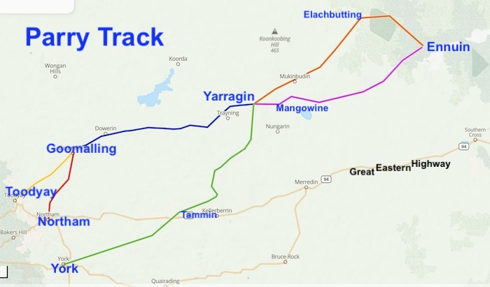
- TO BE AMENDED.
Essentially the Track comprised two parts and six sectors:
To Yarragin and Mangowine
The reliable water sources and Wayside Inns at Yarragin and Mangowine made them natural ‘collection points’ for the many hopefuls travelling to the Yilgarn Goldfields along these four ‘feeder tracks’:
Toodyay-Goomalling
Northam-Goomalling
Goomalling-Yarragin
York-Mangowine
From Yarragin and Mangowine
After the ‘feeder track’ from Goomalling (incorporating the “feeder tracks” from Toodyay and Northam) met at Yarragin travellers could choose to take either Sandalwooders Track through Wilgone and Elachbutting or the Adams Track through Mangowine and Geelakin.
Travellers from York arriving at Mangowine could take the Adams Track or continue north to connect with the Sandalwooders Track.
Sandalwooders Track
This route from Yarragin via Babalin, Wilgoyne, Elachbutting and Walyamoning largely followed existing sandalwooder’s tracks and comprised seven wells.
Adams Track
Though shorter, the route from Yarragin via Mangowine, Dandanning, Cootaning, Geelakin, Chutawalakin and Barcooting to Ennuin was, initially, less popular.
The Complete Track
Essentially the Adams Track was just a shorter route (versus the Sandalwooders Track) to get to Ennuin. It is a part of the Parry Track.
The entirety of the Tracks pass through 13 current day Shires, comprised of total of 48 wells (plus a handful of supplementary. wells), and included three wayside inns. Today, the condition of the wells varies from non-existent and/or unable to be found through to ‘in good condition’ and well-protected.
The combined lengths of the four tracks to Yarragin/Mangowine total xxxx kilometres. The Adams Track – Mangowine to Ennuin is xxx long and the length of the Sandalwooders Track – Yarragin to Ennuin is xxx kilometres. And then there is the short ‘connector’ from Yarragin to Mangowine – xx kilometres.
References and Further Reading
Download GPX file of Parry Track (Toodyay to Goomalling)
Download GPX file of Parry Track (Northam to Goomalling)
Download GPX file of Parry Track (Goomalling to Yarragin)
Download GPX file of Parry Track (York to Mangowine)
Download GPX file of Parry Track (Adams Track)
Download GPX file of Parry Track (Sandalwooders Track)
© Kim Epton and Gary Arcus 2026
492 words, one image.
Feel free to use any part of this document but please do the right thing and give attribution to adventures.net.au. It will enhance the SEO of your website/blog and Adventures.
See Terms of Use.