
-
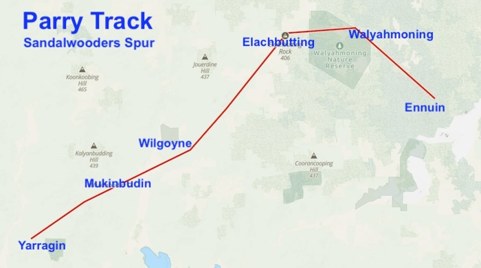
- ROUTE OF SANDALWOODERS TRACK
Sandalwooders Track
Yarragin Well
Well No. 01 on the Sandalwooders Track
Description – Current Day
The well is located at the base of Yarragin Rock, several hundred metres from the existing Yarragin homestead. It is less than 50 metres from the site of the original Yarragin homestead (identified by mulberry, almond and fig trees) but on the opposite side of the creek that has been ravaged into a deep scar on the landscape in recent times. The well has a windmill immediately adjacent to it.
The old homestead and wayside inn site is mostly now just a mound with some evidence of stone remains. The existing homestead and outbuildings are located at the base of Yarragin Rock.
About 100 metres south of the existing homestead and on the opposite bank of the creek is the site and mud brick remains of the c.1905 homestead and a stone well. The circular stone well is partially collapsed and full of debris. Coordinates 31°02’49.20″S, 117° 56 ‘9.6″E
Another 100 metres away to the south is a 1920’s stone constructed plunge dip. (31 02 399S, 117 56 898E).
The stone well is approximately four metres in diameter. Buildup of debris makes it difficult to determine the actual construction details.
It is in poor condition with structural damage from earthquake and perimeter damage.
Location
Yarragin Well is located on the XXXX stock route.
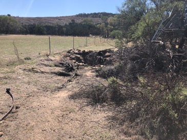
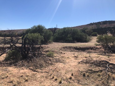
It is 650 metres west of Mount Stevens. It is approximately 400 metres along Kidd Road east from Kununoppin-Mukinbudin Road in a cleared area to the north of the gravel road. The road is signposted to Yarragin Rock (on maps as Mt Stevens) as a site on the Wheatbelt Way tour. Yaragin Well is very close to the farm fence to the north of Kidd Rd and behind some small trees. An old windmill frame is standing next to the well and is visible from the road.
The well stones are evident but broken down into the almost filled-in well. There is clearly moisture there as animals have made paths into the well and probably contributed to the breakdown of the walls.
Coordinates
31 02 25.1S 117 57 01.1E
-31.0418° S, 117.8618° E
Naming and History
John Septimus Roe (1836) and John Forrest (1869) both referred to this area as Yarraging – with Forrest providing extra information that it comprised ‘two bare granite hills’.
The name is derived from the aboriginal word meaning ‘place of height’.
In 1867, Henry Twine and Charles Adams explored the area for grazing land. They took up several pastoral leases of 5000 and 10,000 acres in the district around Barbalin and Yarragin. By 1869, Charles and Jane Adams and James and Janet Ward were occupying Yarragin. They also held a tillage lease for Yarragin, where they would have grown wheat for their own use.
John Forrest arrived at Yarragin on 26 April 1869 and formed a base camp for his journey to establish the fate of the long lost Leichhardt expedition:
“Travelling in about the direction of N.73 deg. E. mag. 73°M] for 28 miles [45km] we reached Yarraging, the furthest station to the eastward, belonging to Messrs. Ward and Adams, where we bivouacked for the night.
April 27th – Bought some rations from Ward & Co., making our supply equal to last three months. Being unable to take the cart any farther, and wishing to take the team of horses with me, I arranged with Ward & Co., to take it to Newcastle for £2. Packed up and left Yarraging with 10 pack and six riding horses.”
In 1889 Surveyor H.S. King established a trig point on the southern most of these two hills and called it Yarragin Rock, a local name which over time has somehow evolved into Mount Stevens – by which name King’s Yarragin Rock is known today.
His field book drawing shows the well as being about 12 feet (3.6 metres) in diameter and about 8 feet (2.4 metres) deep, holding about 3 feet (900mm) of water.
A wayside inn was established at Yarragin Homestead to cater for travellers heading to the goldfields.
In 1909, the site of the Yarragin Well was gazetted Reserve 11228, Avon Location 29150, with an area of 160 acres [65Ha].
The Yarragin Homestead was sold to Barney Lamond in 1904. In 1910, railways came through the area. In 1929, the earliest days of the Great Depression, Alec Hughes went broke and walked away from the property. In 1933 the Woodfield family took up residence, and in 1936, took over to look after the property for the National Bank. In 1949, the North Kununoppin Phone exchange operated from Yarragin Homestead.
The 1968 Meckering earthquake caused a rockslide in Yarragin Well.
The Reserve adjacent to Yarragin Homestead, on the original stock route, was vested in the Water and Rivers Commission in 2003.
In his 1888 Report Parry stated:
“105 miles [108km], Mr A. Butterley’s homestead. . There is a very fair well of water close to an enormous granite hill which could be improved by deepening; on private land. Do not anticipate any difficulty in obtaining a large supply here by sinking to about 15 or 20 feet [4.5 – 6 metres].”
-
- Yarragin Well.
-
- Yarragin Well.
Barbalin Well
Well No. 02 on the Sandalwooders Track
Description – Current Day
Location
In the Barbalin Nature Reserve, south-west quadrant of the intersection of Koorda Bullfinch Road and Barbalin South Road. There is a granite outcrop in the north west corner of this Nature Reserve.
Download the GPX file Yarragin to Barbalin.
Coordinates
30°52’49.20″S, 118° 6’8.13″E
−30.880333, 118.102258
Naming and History
In his 1888 Report Parry stated:
“This is the first really permanent water on the road. It is a fine, stream which appears to come out from the base of a large granite hill, I am told that it is a never-failing spring, and it is certainly one of the best springs I have seen in the colony.”
Unknown Well
Well No. 03 on the Sandalwooders Track
Description – Current Day
Location
Coordinates
Naming and History
Calculling Well
Well No. 04 on the Sandalwooders Track
Description – Current Day
Location
Download the GPX file Barbalin to Calculling.
Coordinates
30° 51′ 47.6″ S, 118° 21′ 21.6″ E
-30.863215 118.355988
Naming and History
In his 1888 Report Parry stated:
“Small tank in granite Very little water. More tanks could be made by excavating between the granite rocks.”
Wilgoyne Well
Well No. 05 on the Sandalwooders Track
Description – Current Day
The well is constructed from granite stones. It is 3.4 metres in diameter and four metres deep.
Location
Off 46 Gate Rd Wilgoyne.
Download GPX file Calculling to Wilgoyne
Coordinates
30° 46′ 6.19″ S, 118° 27′ 16.96″ E
-30.768385 118.45471
Naming and History
The granite stone to construct the well lining was excavated from nearby Wilgoyne Hill. Goldseekers. Sandalwood cutters traversing the area would camp at the Wilgoyne Well to water their stock and replenish their own water supplies.
Later Wilgoyne was similarly a focal for travellers to the Yilgarn goldfields.
The homestead was in place when the Surveyor H.S. King visited the area in 1889. George Lukin had settled at the property with his wife Ada (nee Cooke) in 1874.
The homestead began to fall into disrepair after it was vacated in the 1940s and 1950s.
Malancobbing Well
Well No. 06 on the Sandalwooders Track
Description – Current Day
Location
200 metres east-north-east of Malancobbing Hill and 42 kilometres north-east of Mukinbudin.
Download GPX file Wilgoyne to Malancobbing
Coordinates
30° 40′ 09.8″ S, 118° 32′ 33.1″ E
-30.66938 118.542519
Naming and History
In his 1888 Report Parry stated:
“158 miles. A small natural tank in the rocks on a small flat. Very little water There is a splendid place for a tank in the granite rocks close to this place. Which would only require excavating to turn it into a fine reservoir.”
Adams recorded:
“Malancubbing Well, 10 miles, not permanent.”
Elachbutting Well
Well No. 07 on the Sandalwooders Track
Description – Current Day
Location
Download GPX file Malancobbing to Elachbutting
Coordinates
30°35’36.98″S 118°36’50.64″E
−30.593606, 118.614067
Naming and History
In his 1888 Report Parry recorded:
“ELLACHBUTTING, 161 miles. A well about half a mile on the north side of road, at the foot of a large granite hill. This is a very fair supply but Mr Adams informs me that it is not permanent, but very seldom fails. I believe a few charges of dynamite would greatly increase the supply.”
Adams recorded:
“Ellachbudding, 6 miles, well about 1 mile from road, close to hill on N.E. side.”
-

- Elachbutting Well.
-

- Elachbutting Well
-

- Elachbutting Well
-

- Elachbutting Well 2015.
Walyahmoning Well
Well No. 08 on the Sandalwooders Track
Description – Current Day
Location
Download GPX file Elachbutting to Walyahmoning
Coordinates
30° 37′ 57.03″ S, 118° 45′ 10.81″ E
-30.632508 118.753002
Naming and History
In his 1888 Report Parry stated:
“This is a remarkable mass of granite rocks, forming a basin, almost entirely surrounded by bald granite hills. There is only a little water in a small rock hole. By excavating, several good tanks could be made at small cost, but I am of the opinion that a spring could be found at the base of one of the hills, as occurs in other instances in these granite hills.”
Ennuin
Well No. 09 on the Sandalwooders Track
This was the goal for the hopefuls travelling to the goldfields.
Description – Current Day
Location
Download GPX file Walyahmoning to Ennuin
Coordinates
Naming and History
In his 1888 Report Parry wrote:
“ENUIN, 191 miles. Mr. G. Lukin’s old homestead. There is a tank in the granite rocks, which has so far been supplying the prospectors with water; it is now however nearly dry. It could be made much larger and almost an unlimited amount of water conserved by making more tanks.. There is however a well which Mr. Lukin sank to a depth of 42 feet, and left off on reaching porous sand stone. I would suggest that in the first place this well be put down deeper, until the granite is reached, when I feel sure a good supply will he obtained. Failing this, however, there is every facility for tank making. Mr. Lukin has two other wells about seven miles from Enuin, but the supply is, I believe, limited.”
Adams recorded:
“Enuin, I8 miles, water not permanent.”
References and Further Reading
Go to Parry Track
Go to Toodyay-Goomalling Feeder Track
Go to Northam-Goomalling Feeder Track
Go to Goomalling-Yarragin Feeder Track
Go to York to Mangowine Feeder Track
Go to Adams Track
© Kim Epton and Gary Arcus 2026
1689 words, six photographs and one image.
Feel free to use any part of this document but please do the right thing and give attribution to adventures.net.au. It will enhance the SEO of your website/blog and Adventures.
See Terms of Use.