
-
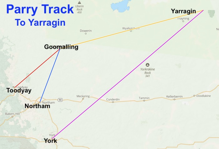
- PARRY TRACK – TO YARRAGIN
York to Mangowine
York Well
Well No. 01 on the York to Mangowine Track
Description – Current Day
Location
Coordinates
Naming and History
Malbelling Well
Well No. 02 on the York to Mangowine Track
Description – Current Day
Location
Coordinates
Naming and History
In his 1888 Report Parry recorded:
From York to Malbelling 10 miles[16 km]. There is a good supply of water in Mr Beckit’s well. There is a Government reserve here where, if a well were sunk a similar supply would be likely obtained.
Skeleton Pool Well
Well No. 03 on the York to Mangowine Track
Description
Location
This is a well on the Mortlock River South. Given that it is at the end of Flea Pool Road it’s historical name may have fallen into disuse.
Coordinates
31° 48′ 08″ S, 117° 01′ 32″ E
-31.802222, 117.025556°
Naming and History
The historical name for this pool entered official records prior to 1881.
In his 1888 Report Parry recorded:
Skeleton Pool, 16 miles [26km]; Fair supply of water in pool. Could be very much improved by cleaning out and making small dam. I also think that water could be got by sinking.
Belmunging Pool Well
Well No. 04 on the York to Mangowine Track
Description
Location
Coordinates
Naming and History
In his 1888 Report Parry recorded:
Belmonging, 22 miles [35 km], small pool of water could be improved by making a small dam. A well, however, would be the best, A great number of the settlers are trying to get a well sunk at this place as it is a good baiting [feeding] distance from Youndegin.
Youndegin Well
Well No. 05 on the York to Mangowine Track
Description
The well was restored by the Cunderdin Historical Society prior to 1982 (possibly 1975). It is in poor condition and in need of cleaning out.
Wells that are fenced are generally in better condition than those unfenced.
Location
The well is located 40 metres east of the old Youndegin Wayside Inn, very close to the road. It is signposted.
Coordinates
31° 47′ 22.78″ S, 117° 19′ 39.50″ E
-31.78966 117.32764
Naming and History
The name for this locality was derived from nearby Youndegin Hill, first recorded by Surveyor/Explorer C.C. Hunt in March 1864.
Hunt used Youndegin Well regularly on his four expeditions eastwards.
A Police Station was established at Youndegin in 1866 and became an important stop on the road to the east. Its importance increased during the gold rush to Yilgarn and later rushes in the 1890s to Coolgardie, Kalgoorlie and beyond..
Tammin Well
Well No. 06 on the York to Mangowine Track
Description
The restored well at Tammin (signposted as Hunt’s Well) is more than likely a well that was constructed in the 1890’s gold rush era or later. The existing well bears no relationship to the measurements of the well as stated by Hunt. Regardless of its authenticity or otherwise it is quite often confused with nearby Tammin Tank.
It was an important stop for travellers to the Yilgarn goldfields and, later, an equally important source for those heading to Coolgardie, Kalgoorlie and surrounds.
Location
Hunt’s Well is located south of the wheatbelt town of Tammin on the western side of Tammin Rock, 50 metres south-east of Goldfields Road.
Coordinates
31° 40′ 7.22″ S, 117° 29′ 36.68″ E
-31.66867243, 117.4935230
Naming and History
When Surveyor/Explorer Charles Hunt first moved through this area in 1864 he used the native well at Tammin Rocks. In February 1865, during his third expedition, his construction party of six Pensioner Guards and 10 convicts stoned up the well.
-

- Tammin Well
-

- Tammin Well Plaque December 1995.
Naraline Spring
Well No. 07 on the York to Mangowine Track
Description
Naraline Spring/Soak has been ploughed into a paddock and no longer exists.
Location
On a farm. 174 kilometres (straight line) ENE of Perth. Five kilometres (straight line) WNW of Kellerberrin.
Coordinates
31° 37′ 7.02″ S, 117° 40′ 12.66″ E
-31.618618 117.670182
Naming and History
-

- Tony at Naraline Spring December 1995.
-

- Norm at Naraline Spring December 1995.
Milgannine Well
Well No. 08 on the York to Mangowine Track
Description
Location
Coordinates
31° 32′ 05.3″ S, 117° 43′ 05.5″ E
-31.534815 117.718182
Naming and History
In his 1888 Report Parry stated:
“Massinghams’ homestead 67 miles [108 km]. Two wells of permanent water. Mr. Massingham states that he has watered a flock of 2000 sheep at one of these wells all the summer. This well is not far from large granite hill.”
Woolering Well
Well No. 09 on the York to Mangowine Track
Description
Location
Coordinates
31° 31′ 26.2″ S, 117° 43′ 31.4″ E
-31.523956 117.725402
Naming and History
In 1888 Parry stated in his Report:
“67 miles [108 km], another well of permanent water, only 5ft [1.5 metres] deep. Spring comes out of a fissure in the granite.”
Nalyaring Well
Well No. 10 on the York to Mangowine Track
Description
Location
Located in the Burges Spring Nature Reserve, 730 metres south-east of Burges Spring and 320 metres south-east of Nalyaring Rock which was named by C.C. Hunt in 1864. Note that Burges Spring was not named/recorded until Surveyor C.M. Denny recorded it in 1892 whereas Nalyaring was known from 1864.
Coordinates
31° 28′ 53.9″ S, 117° 41′ 29.2″ E
-31.481652 117.691449
Naming and History
Parry stated:
“72 miles [116km]. A splendid well of permanent water at foot of small hill. Remains of an old homestead and a very good orchard. A more direct road could be got from Tammin to Nalyering Rook but Mr. Massingham states the water supply would not be so good.”
Nanyanine Well
Well No. 11 on the York to Mangowine Track
Description
Location
Coordinates
31° 24′ 29.1″ S, 117° 42′ 35.9″ E
-31.40808 117.70998
Naming and History
No information found.
Durokoppin Well
Well No. 12 on the York to Mangowine Track
Description
Location
Coordinates
31° 23′ 17.3″ S, 117° 44′ 38.6″ E-
-31.388131 117.744058
Naming and History
The name for this well entered Crown Lands and Survey Office official records when Surveyor H.S. King recorded it in 1889 although clearly Parry was aware that it was a (slightly different) local name in prior use well before King’s action.
In 1888 Parry recorded:
“Durakopping 79 miles [127 km]. Well, but only a soak. Not much water at present. Would advise that this be deepened.”
Kodj Kodjin Well
Well No. 13 on the York to Mangowine Track
Description
Location
Coordinates
31° 20′ 23.2″ S, 117° 48′ 34.1″ E
-31.339787 117.809477
Naming and History
An early spelling of the name was Cotcherootching.
Parry stated:
“86 miles [138 km] A little water in shallow well at foot of hill but it is only a soak and not permanent. This is a very good camping ground with plenty of feed. I have no doubt that water could easily be got by sinking.”
Tootaning Well
Well No. 14 on the York to Mangowine Track
Description
Location
Coordinates
31° 17′ 22.2″ S, 117° 53′ 53.4″ E
-31.289496 117.898154
Naming and History
Parry stated:
“94 miles [151 km]. No water, but good place for a dam in the gully, also a likely place for well.”
Walcancobbing Well
Well No. 15 on the York to Mangowine Track
Description
Location
Coordinates
31° 14′ 27.6″ S, 117° 56′ 03.6″ E
-31.240994 117.934345
Naming and History
The name for this well entered Crown Lands and Survey Office official records when Surveyor H.S. King recorded it in 1889 although clearly Parry was aware that it was a local name in prior use when he recorded it the year before King.
Parry stated:
“98 miles [158km]. Remains of an old homestead. Water in a very peculiar rook hole on the top of a mass granite and appears to extend for a considerable distance under the rock. This is said by some to have been a permanent supply at one time,, but I could not get any very definite information about it. There was plenty of water when I was there.”
Mangowine Wayside Inn and Well
At this point travellers heading to the goldfields had to decide whether to take the Adams Track along the shorter route to Ennuin or strike out north to connect with the Sandalwooders Track.
The York to Mangowine Feeder Track comprises 15 wells along a distance of about 200 kilometres.
References and Further Reading
Download the GPX file of York to Mangowine Track
Go to Parry Track
Go to Toodyay-Goomalling Feeder Track
Go to Northam-Goomalling Feeder Track
Go to Goomalling-Yarragin Feeder Track
Go to Sandalwooders Track
Go to Adams Track
© Kim Epton and Gary Arcus 2026
1177 words, yy photographs, one image.
Feel free to use any part of this document but please do the right thing and give attribution to adventures.net.au. It will enhance the SEO of your website/blog and Adventures.
See Terms of Use.