
The Adams Track is a spur of the Parry Track described by C.F. Adams of Mangowine only two months after H.E. Parry delivered his Report on Routes to the Yilgarn Hills. The Adams Track is slightly shorter than the spur known as the Sandalwooders Track.
Travellers on the Adams Track started from Mangowine and headed to Dandanning although they had the option of heading north from Mangowine to connect with the more established Sandalwooders Track.
Mangowine Well
Well No. 01 on the Adams Track
Mangowine was an important junction on the Parry/Adams Track. It was the site of a Wayside Inn and was renowned as a permanent supply of water.
Description – Current Day
Location
The well is located on the opposite side of Karomin Road to the homestead.
Coordinates
31° 2′ 51.22″ S, 118° 6′ 29.92″ E
-31.047561, 118.108311
Naming and History
In 1875, Charles Adams took up a grazing lease at Mangowine, and he and his wife, Jane, moved to Mangowine from Yarragin.
The most important asset at Mangowine was the soak located below the base of the shelving rock. When this soak was deepened, the water flowed at a depth of 500 mm, however in dry seasons the supply was unreliable, and despite other wells being sunk, many trips had to be made more than 16 kilometres back to the site of their previous home at Yarragin to source precious water.
Gold was discovered at nearby Moujakine in 1887, and led to the opening of the Yilgarn fields in 1888.
Prospecting teams passed through Mangowine on their way to the goldfields, and life became even more hectic at Mangowine.
To cater for this passing trade, a wayside inn was built alongside the homestead and a licence was granted in 1889.
The completion of the railway through Merredin in 1893 diverted the gold rush traffic.
Mangowine was restored by the National Trust and opened to the public in 1973.
Dandanning Well
Well No. 02 on the Adams Track
Description – Current Day
The well is fenced with a locked gate. No water is apparent in the well. It appears to be in good condition, although becoming overgrown.
Location
Located in the south-east corner bush area of Dandanning Road and Cornish Road intersection, opposite Karomin Road. Access is by dirt track from Dandanning Road and Cornish Road.
Coordinates
31° 00′ 42.0″ S, 118° 10′ 49.7″ E
-31.011667, 118.180472
Naming and History
In 1888 Parry stated:
“Dandannie 122 miles, permanent Well of water”.
-
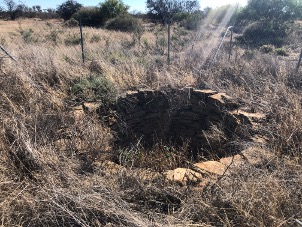
- Dandanning Well
-
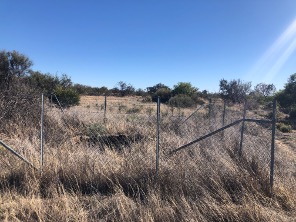
- Dandanning Well
Cootaning Well
Well No. 03 on the Adams Track
Description – Current Day
Possibly in an area of bush in the south-west corner of the intersection of Andrews East Road and Stockton Road. Needs site exploration.
Location
Coordinates
31° 02′ 27.8″ S, 118° 21′ 24.2″ E
-31.04106 118.356709
Naming and History
In 1888 Parry reported:
“… a tank with a little water, which might be enlarged.”
Geelakin Well
Well No. 04 on the Adams Track
Description – Current Day
As 2024 this site comprises a large concrete circular tank fed by a perimeter wall on the rock behind it. The tank is clearly being used, probably for farm and fire water. The area is damp and has thick bush around it which may hide evidence of the original well.
Location
Coordinates
30° 58′ 51.5″ S, 118° 37′ 33.1″ E
-30.980964, 118.625848
Naming and History
In 1888 Parry stated:
“… well, permanent water. Between Cootanning and Gilakim water might be obtained by sinking.”
Chutawalakin Well
Well No. 05 on the Adams Track
Description
Location
Coordinates
30° 55′ 40.5″ S, 118° 45′ 36.2″ E
-30.927907, 118.760044
Naming and History
The name for this well entered Crown Lands and Survey Office official records when Surveyor H.S. King recorded it in 1889. In his Report a year ealier Parry used the name Jatawolkin. Various renderings of the aboriginal pronunciation of the name for the feature were used before the current name was adopted.
In his 1888 Report Parry stated:
“Jatawolkin 165 miles. There is a good supply, but a little brackish.”
Barcooting Well
Well No. 06 on the Adams Track
Description
Barcooting Well is a large stone well built around an original soak.
Location
Coordinates
30° 48′ 53.06″ S, 118° 52′ 29.64″ E
-30.814738, 118.874901
Naming and History
The well was constructed some time after 1887.
It was was used by early prospectors, including the discoverers of Southern Cross. The
subsequent well and dam were used by farmers and travellers.
Eenuin Well
Well No. 07 on the Adams Track
Description
Enuin is the original historical name for this area, Ennuin is the current standard spelling for the locality and station, and Eenuin is used specifically for the mine and associated well nearby.
Location
Download GPX file.
Coordinates
30° 44′ 47.8″ S, 118° 59′ 45.9″ E
-30.746623, 118.996093
Naming and History
In 1888 Parry stated:
“Mr G. Lukin’s old homestead. There is a tank in the granite rocks, which has so far been supplying the prospectors with water; it is now however nearly dry. It could be made much larger and almost an unlimited amount of water conserved by making more tanks.. There is however a well which Mr Lukin sank to a depth of 42 feet, and left off on reaching porous sand stone. I would suggest that in the first place this well be put down deeper, until the granite is reached, when I feel sure a good supply will he obtained. Failing this, however, there is every facility for tank making. Mr. Lukin has two other wells about seven miles from Enuin, but the supply is, I believe, limited.”
References and Further Reading
Download GPX file of the Adams Track.
Go to Parry Track
Go to Toodyay-Goomalling Feeder Track
Go to Northam-Goomalling Feeder Track
Go to Goomalling-Yarragin Feeder Track
Go to York to Mangowine Feeder Track
Go to Sandalwooders Track
© Kim Epton and Gary Arcus 2026
965 words, yy photographs, one image.
Feel free to use any part of this document but please do the right thing and give attribution to adventures.net.au. It will enhance the SEO of your website/blog and Adventures.
See Terms of Use.