
-
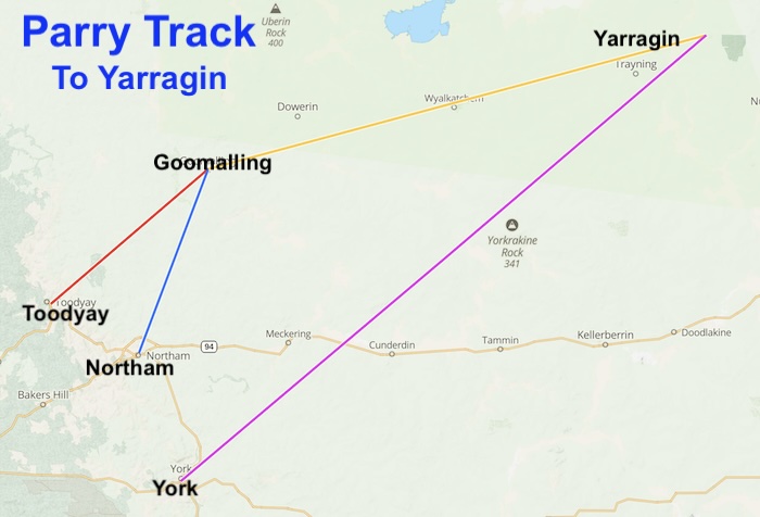
- PARRY TRACK – TO YARRAGIN
Northam to Goomalling
Beering Well
Well No. 01 on the Parry Track – Northam to Goomalling
Description – Current Day
Not known.
Location
Located on a farm on Beering Road, 700 metres west of Northam-Pithara Road and north of the town of Northam.
Download GPX file Northam to Beering Well.
Coordinates
31° 34′ 5.08″ S, 116° 41′ 3.93″ E
-31.568077 116.684424
Naming and History
In his 1888 Report Parry stated:
“… well of permanent water on left hand aide of road, owned by Richard Dudley. This is a regular watering place for teams.”
Jennapullin Well
Well No. 02 on the Parry Track – Northam to Goomalling
Description – Current Day
Not known.
Location
The well is located in a paddock adjacent to track, 600 metres off the Northam-Pithara Road, Jenapullen.
Download GPX file Beering Well to Jennapullin Well.
Coordinates
31° 31′ 38.59″ S, 116° 42′ 52.84″ E
-31.527385 116.714677
Naming and History
In his 1888 Report Parry stated:
“Well 20 chains [400 metres] on left of road suitable for stock but small supply owner, D. Morrell. There is also a well about 300 yards [275 metress]on same side of road which, if deepened would likely yield a good supply. At 15.5 miles [25 kilometres] there are 2 wells about 400 yards [365 metres] on the left side of the road on government reserve. One of these wells is considered permanent.”
Guilguilling Well
Well No. 03 on the Parry Track – Northam to Goomalling
Description – Current Day
Ascertaining the existence/location of this well is problematic.
Location
Position doubtful.
Download GPX file Jennapullin Well to Guilguilling Well.
Coordinates
31° 26′ 32.86″ S, 116° 47′ 55.38″ E
-31.442462 116.798716
Naming and History
Parry stated in his 1888 Report:
“Mr J. Eaton’s. Two very good wells. This is a regular stopping place for team. Water easily obtained by sinking.”
Mindara Well
Well No. 04 on the Parry Track – Northam to Goomalling
Description – Current Day
Not known.
Location
The well is located 100 metres west of the Northam-Pithara Road and 800 metres south-south-east of Hulongine Road, south of Goomalling.
Another pioneer water source, Margerin Well is nearby.
Download GPX file Guilguilling Well to Mindara Well.
Coordinates
31° 22′ 28.28″ S, 116° 48′ 53.34″ E
-31.374523 116.814816
Naming and History
In his 1888 Report Parry stated:
“… permanent well of water suitable for stock. 300 yards [275 metres] eastern side of road. Owner Joseph Lockyer.”
Blimmining Well
Well No. 05 on the Parry Track – Northam to Goomalling
Description – Current Day
Location
Located one kilometre north-west of Northam-Pithara Road, Konnongorring. It is four kilometres south of the town of Goomalling.
Download GPX file Mindara Well to Blimmining Well.
Coordinates
31° 20′ 8.16″ S, 116° 49′ 23.27″ E
-31.3356 116.823131
Naming and History
In his 1888 Report Parry stated:
“… 2 wells close to road on left side. Sheep are watered at these all year of late years. At one time supply was not good.”
Slater’s Well at Goomalling
This reliable water source was the focal point for travellers coming from Toodyay and Northam. Those leaving from York travelled direct to Yarragin.
The Northam to Goomalling Feeder Track comprises five wells along a distance of about 50 kilometres.
References
Go to Parry Track
Go to Toodyay-Goomalling Feeder Track
Go to Goomalling-Yarragin Feeder Track
Go to York-Mangowine Feeder Track
Go to Sandalwooders Track
Go to Adams Track
© Kim Epton and Gary Arcus 2026
597 words, one image.
Feel free to use any part of this document but please do the right thing and give attribution to adventures.net.au. It will enhance the SEO of your website/blog and Adventures.
See Terms of Use.