
An immigrant and settler, C.C. Hunt contributed immensely to the Colony of Western Australia at a time when the interior, and even the near interior was totally unknown.
Charles Cooke Hunt was born at Brighton, Sussex, England in 1833, and later joined the Royal Navy, acquiring his Masters Certificate in 1859. He fell from a yardarm to the deck, broke his kneecap and was pensioned off.
Early Exploration
C.C. Hunt arrived in Western Australia in early 1863 and worked as mate on the New Perseverance, a coastal trader. In February 1863 he joined a sea and land expedition in the De Grey and Nickol Bay area.
First Expedition to the East
In 1863 Henry Maxwell Lefroy had completed his expedition to the area known as Lake Lefroy near Kambalda. The York Agricultural Society pushed for further exploration. Hunt’s uncle, prominent farmer J.T. Cooke, promoted Hunt as an ideal expedition leader and he was chosen for the job.
Early in 1864 C.C. Hunt lead his first expedition, a flying visit to the interior. His party included Robert Hardey, Edward Robinson, trackers Cowitch and Tommy Windich. This expedition left York on 15 March 1864 and returned 16 April 1864 after travelling as far as the Koolyanobbing Ranges.
Second Expedition
His role on his second expedition, 9 July to 4 November 1864, was to explore the country east of York to determine potential for agricultural and pastoral activity. His party of seven travelled 560 kilometres to the east. During this trip he named Hampton Plains, after Governor Hampton.
-
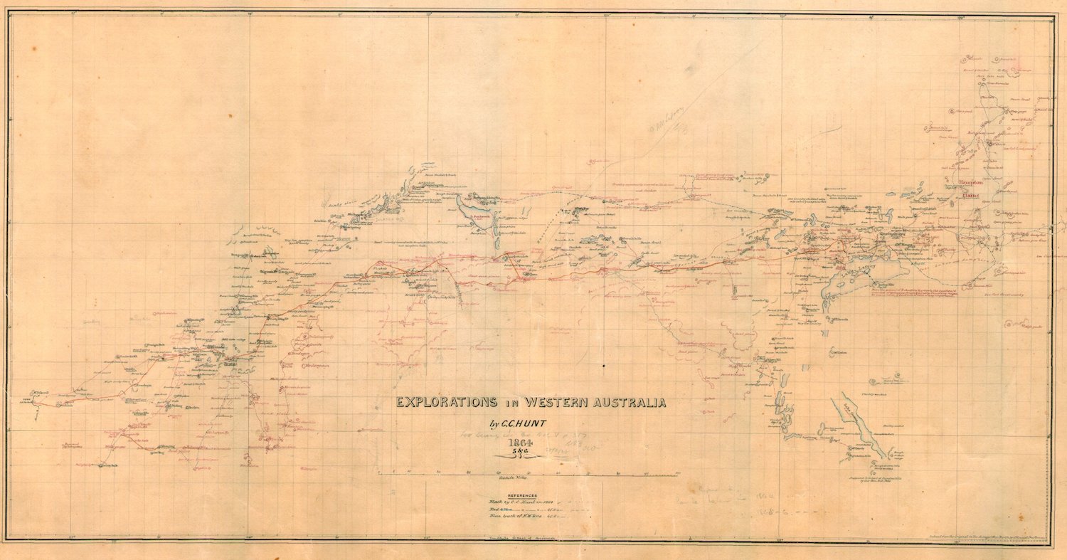
- Map of Explorations in WA by explorer/surveyor C.C. Hunt.
Third Expedition
On his third expedition, 3 January to 4 October 1865, he was charged with clearing a track to the east and with sinking wells at convenient intervals. He had a party of six pensioner soldiers, 10 probationary prisoners and a native tracker. This track later became known as Hunts Track. Hunt had developed a permanent supply of water for 500 kilometres from York, by building wells, tanks and dams as far as Lake Lefroy.
Explorations in Western Australia by surveyor/explorer C.C. Hunt
Fourth Expedition
His fourth and final expedition, 9 July to 25 October 1866, was his best-equipped. Hunt’s party totalled 17. His role was to:
- Complete the track to Slate Well and on the way to build as many dams, wells and tanks as there was potential
- Survey any blocks suitable for pastoral holdings
- Examine the land further east to see if more could be taken up between Hampton Plains and the South Australian border.
Little rain had fallen that season and the expedition took place under drought conditions.
Ill Health
The heavy strain of the exploration work seriously affected Hunt’s health. He was advised by the Colonial Surgeon to take leave and rest. In his diaries Hunt occasionally mentioned he was too sick for work.
In 1867 he went to Geraldton and worked as a road surveyor. Hunt became ill in December 1867 and entered hospital in January 1868, dying of heart disease on 1 March 1868 at the age of just 35. He left a wife and two children. He was buried at Geraldton.
Hunt Track and Wells
Hunt’s track clearing and well making expeditions resulted in a spring cart width track that linked a series of 26 wells, dams, tanks, soaks and other seasonally reliable water holes, securing a safe, reliable route to the Hampton Plains.
This cleared strip became known as Hunt Track, opening up the interior to explorers and other travellers and which, some 30 years later, became the basis for the route to the Eastern Goldfields. Five years earlier some of the wells just east of York enabled hopefuls to access the Parry Track and get to the Yilgarn Goldfields
Hunt’s wells were generally found at the base of rocky granite outcrops, with the development of wells eastwards beyond Depot Hill hampered by a change in geological formation from granite to immense beds of slate, pipeclays and quartz.
Pensioner soldiers and probationary convicts constructed the wells. Hunt explored further ahead of his well-building team. While most of the wells built were relatively shallow, their excavation took hundreds of man hours and up to a month at a time. The circular dry rock wells that have stood the test of time are beautiful examples of the stonemason’s art.
Select Bibliograpy
Explorations – Print Publications
Hunt was involved with an expedition of exploration in the north-west of Western Australia in 1863 after which he led four explorations eastward of York between 1864 and 1866.
Due North: The Exploration of the North West of Western Australia
Peter Bridge
Series Editors Peter Bridge and Kim Epton
An 890 page Volume in the Western Australian Exploration series that includes transcripts of Hunt’s two expeditions in the North West.
Exploration Eastwards 1860-1869
Peter Bridge and Kim Epton
A 576 page Volume in the Western Australian Exploration series that includes transcripts of Hunt’s four expeditions to the east.
C.C. Hunt’s Koolyanobbing Expedition
Kim Epton
A translation of Hunt’s York to Koolyanobbing expedition to modern maps, including modern-day rendering of place names and features.
Online Resources
C.C. Hunt – Explorer and Surveyor
Adventures website.
Charles Cooke Hunt
Kim Roberts – Online Australian Dictionary of Biography – 2006
Charles Cooke Hunt
Eric Hancock – Outback Family History website.
C.C. Hunt – Explorer and Surveyor
Explorers’ Wells and Tracks website.
Charles Cooke Hunt
WA Now and Then website.
Walk of Fame
City of Kalgoorlie Boulder.
Explorations
C.C. Hunt – Explorer and Surveyor
Adventures website.
Spinifex Range
Adventures website
Hunt Track beyond the accepted end of the Track.
Hunt Track
In accordance with Guidelines for the Consistent Use of Place Names the genitive/possessive apostrophe is disregarded. Hunt Track not Hunt’s Track. Hunt Track is the oldest, still existing track in Western Australia. It is the second longest Track in Western Australia, after the Canning Stock Route.
Hunt Track
Explorers’ Wells and Tracks website.
Hunt Track
Adventures website.
Hunt Track – Gnarlbine to Yerdanie
Adventures website
Hunt Track between Gnarlbine and Yerdanie, including woodlines and the File Tree – 2018.
Hunt Track from Yerdanie to Gnarlbine 2018
Explorers’ Wells and Tracks website.
Hunt Track – Yerdanie to Gnarlbine 2020
Explorers’ Wells and Tracks website.
Gus Luck Track Reprise
Short section of Hunt Track at Sandford Rocks.
On the Track
WA Museum website.
Western Australia’s goldfields, gold rushes and people who lived through it.
The Planned Completion of Hunt Track from Yerdanie to Gnarlbine
Explorers’ Wells and Tracks website.
Completion of the track refurbishment between Gnarlbine and Yerdanie.
Trains Planes and 4WDs
Adventures website.
Woolgangie to Gnarlbine, then Nepean to Goldfields HIghway.
West of the Nullarbor
Adventures website.
Hunt Track from Gnarlbine to Woolgangie.
Hunt Track Videos
Charles Hunts Track and Wells 1
Doug Hardman
Retired professional does a professional presentation.
Charles Hunts Track and Wells 2
Doug Hardman
Excellent Presentation.
Charles Hunts Track and Wells 3
Doug Hardman
Quality contribution to Hunt’s legacy.
Charles Cooke Hunt’s Track and some of his wells. Part 1
WA4WD
While there is no new information in this video it is an honest presentation that follows 42 kilometres of the 1160 kilometres Hunt Track, the second longest track in Western Australia after the Canning Stock Route.
Hunts Track Part 2
WA4WD
Part 2 of above.
Hunts Track
Alan McCall (aka Outback Yonder, aka Equinox)
Unparalleled knowledge of David Wynford Carnegie’s amazing two desert trips is just the start of Alan’s extensive bush history experience. This video showcases an important part of the 1160 km Hunt Track that was re-opened in 2018-19.
Hunting Hunt Track
Geoff Lewis
This guy had no idea where he was and no idea of the explorer he was following but he made a video anyway.
Hunt’s Wells
When referring to Hunt’s Wells the use of the possessive apostrophe is perfectly acceptable – unlike reference to Hunt Track where the possessive apostrophe is eschewed.
Hunt created 26 wells between York and Kambalda in 1865-66.
In 1864 Hunt explored many hundreds of kilometres further east than the chain of wells that was constructed in 1865-66.
The Wells of Explorer C.C. Hunt
Explorers Wells and Tracks website
A listing of Hunt’s Wells from York to the terminus of his Well Track.
The Wells of Charles Cooke Hunt
Claire Young
An assessment of each of Hunt’s Wells, available as a downloadable PDF, that includes 1980’s images of wells.
Hunt’s Wells Group
Heritage Council of Western Australia website.
An assessment of 34 wells.
Hunt for Hunt’s Wells 2008
Explorers’ Wells and Tracks website.
A comprehensive survey of many of Hunt’s Wells in the Eastern Goldfields.
Hunt for Hunts Wells 2021
Explorers’ Wells and Tracks website.
Granite Monsters
Adventures website.
Inspection of Totadgin, Burracoppin, Boodalin, Moorine, Kodjerning, Koorkoordine, and Weowanie rocks and wells in 2019.
A Better Way to Coolgardie
Adventures website.
A visit to six wells before a drive along a section of Hunt Track.
Lake Douglas to Moorine Rock
Inspection of Gnarlbine, Yerdanie, Karalee, Kodjerning, and Moorine rocks and wells in 2022.
Burracoppin Well
Explorers’ Wells and Tracks website.
Yerdanie Well
Explorers’ Wells and Tracks website.
Yerdanie Well
Explorers’ Wells and Tracks website.
The Wells of Explorer C.C. Hunt.
Boodalin Soak
Explorers’ Wells and Tracks website.
Slate Well – Well No. 24
Explorers’ Wells and Tracks website.
Well Refurbishments
Some of Hunt’s Wells have been refurbished.
Burracoppin Well Refurbishment
Explorers’ Wells and Tracks website
This was one of the wells refurbished in 2016.
Doodlakine Well Refurbishment
Explorers’ Wells and Tracks website.
Doodlakine Well was refurbished in 2016.
Kodjerning Well Refurbishment
Explorers’ Wells and Tracks website.
This was a major refurbishment by the Cockburn 4WD Club and the Mitsubishi 4WD Owners Club of WA, carried out in 2021.
Koorarawalyee Well Refurbishment
Explorers’ Wells and Tracks website.
This 2016 project was the first of Hunt’s Wells to be refurbished.
Moorine Well Refurbishment
Explorers’ Wells and Tracks website.
This well was refurbished in 2021 – at the same time as Kodjerning Well.
Totadgin Well Refurbishment
Explorers’ Wells and Tracks website.
Refurbished in 2016.
Bicentennial Plaque Relocation
A Better Way to Coolgardie
Adventures website.
A visit to six wells including Karalee to where the Bicentennial plaque was moved before a drive along a section of Hunt Track.
Plaque Relocation Project
Explorers’ Wells and Track website.
An account of how the Bicentennial plaque was relocated.
Karolin Rock
Explorers’ Wells and Tracks website
A description of the rock and wells from where the Bicentennial plaque was retrieved.
Bicentennial Plaque Relocation
Explorers’ Wells and Tracks website.
An account of how the Bicentennial plaque was relocated.
Hunt for Hunt’s Well 2021
Explorers’ Wells and Tracks website.
En route to complete work on Hunt Track and wells there was time to check that the relocated Bicentennial Plaques were present and upright.
Wells, Pipelines and Water
Adventures website.
A quick visit to Karalee to check the relocated plaques.
Publications Referencing Hunt
Local Heritage Survey 2022
Shire of Merredin.
Pages 14, 19, 26, 63-65, 70, 79-81, 88, 119-121, 127-128, 138-139.
A Thematic History of Western Australia
Heritage Council of Western Australia.
Pages 9, 11 and 43.
When you copy from one source it plagiarism. When you copy from many it’s research. Either way, please give acknowledgment to the appropriate source.
© Kim Epton 1987-2026
1806 words, one image
Feel free to use any part of this document but please do the right thing and give attribution to adventures.net.au. It will enhance the SEO of your website/blog and Adventures.
See Terms of Use.