The Western Australia Day long weekend of 2024 was an opportunity to visit my famous mate in Kalgoorlie – legendary prospector/miner Scott Wilson and do a Road Trip to some places we had never previously visited.
We left Kalgoorlie on Friday morning, heading east along the Trans Australia Railway Access Road. 75 kilometres out we called in to the abandoned Avoca Downs homestead.
Avoca Downs
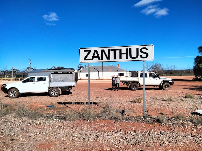
Zanthus
After a quick stop for lunch at Coonana it was on to Zanthus. With the modernisation of maintenance of the railway by the managers ARTC, most of the fettler sidings have closed. However, Zanthus has been developed as a maintenance centre.
- No doubting where we were.
Lake Boonderoo
We arrived at Lake Boonderoo around 3.30 p.m. and made our way to an elevated area on the east side of the lake.
- Looking west over Lake Boonderoo from viewpoint on eastern shore.
It was a good spot to camp. Boonderoo means ‘stony country’ in the Tjeraridja language.
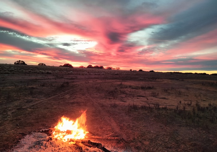
- Sunset at Boonderoo
Lake Bed
The next morning we walked down the hill and then 1500 metres to the small amount of water in the lake. Our disappointment in not finding the lake full was countered by the unusual sights encountered on the dry lake bed.
- Bungarra hole found on the walk to the water.
The lake bed was fascinating. Encrustations on long submerged trees and plants now exposed to the elements were amazing. Ducks and small birds were common. There were small fish in the water.
- Kim at the lake bed.
All too soon it was time to head back to the vehicles and continue our journey. Lake Boonderoo is amazing.
Boghole
Just south of Lake Boonderoo our way was blocked by a boghole. Water spread a considerable distance to the east.
- Water spread for a considerable distance to the east.
The water across the track looked shallow, easy to traverse and fairly innocuous, however, an inspection on foot showed it to be extremely boggy. The was evidence of large animals – possibly cattle or camels – getting bogged on the edge of the track.
- The water across the track looked shallow and fairly innocuous, however, an inspection on foot showed it to be extremely boggy.
The only way around the mud was through the bush to the west of the track. It was open country, firm and easy to negotiate.
The track we were on was good. Dead straight (south), uncorrugated, wide and no surprises.
- Three wild dogs were hunting down a roo.
- The dogs looked like they were a dingo/German Shepherd cross.
- They were initially inquisitive.
More information about rangelend management/protection.
Towards the end of the track south we came across what was possibly a station outcamp or, more likely, a dogger’s camp.
Rawlinna-Balladonia Track
The track south from Lake Boonderoo intersects with the Rawlinna Balladonia Track at a windmill and yards. As is often the case when tracks intersect at yards, finding the way forward can be a challenge. And so it was for us.
Spring Camp Dam Fossils
Just after lunch we saw some earthworks not far off the track so we drove over to check it out. It was the Spring Camp Dam. So what. Just another watering hole.
- Spring Camp Dam
Like all good prospectors Scott poked around examining all the disturbed rocks. And found a bunch of fossils!
The country here is east of the ancient Yilgarn Craton and clearly part of a much younger, former sea bed.
So, did the creators of this dam make it for watering stock or were they seeking fossilised slabs that could be sold as tables or other artefacts?
Monita Outcamp
We moved on south-west. More yards and more confusion and uncertainty. We tried the track continuing south-west without success. I decided to head back to the yards, from which point we drove due west to Monita Tank (named as Monta Tank on some maps). This is an abandoned outcamp. Dongas, vehicles, and sheds in various states of decrepitude and neglect. The scale of the operation was substantial and indicated that the track from here to Balladonia would be easy to follow.
The sun was getting low in the sky and it was time to think about finding a campsite. Scott suggested North Rocks. They were at a convenient distance and only a couple of kilometres off our Balladonia-directed course.
North Rocks
North Rocks is an open, pasture like area of about 20 acres, devoid of trees. Camp anywhere. The conglomeration of rocks consists of North Rocks, McPherson Rock and Wornanya Rock.
Some big logs that had to be towed in made for a great fire.
- Sunrise at North Rocks.
- Unnamed tank near the turnoff to North Rocks.
Noondoonia
Leaving North Rocks we made our way back to the Track and then headed south-west to the abandoned Noondoonia Station.
- Derelict shearing shed at Noondoonia.
Afghan Rock
As we arrived at Afghan Rock, an historic location with a dark past, we knew we were not far from the Eyre Highway and Balladonia roadhouse.
- Gnamma at Afghan Rock.
- Surface water at Afghan Rock.
After fuel and coffee at the Balladonia Roadhouse we headed west on the blacktop to Buldania.
Buldania
The predicted rain arrived as we were investigating Buldania. This abandoned mining centre covers a large area.
- Poppet head.
- Shafts and mullock heaps.
- Hopper and conveyor.
The track was slippery. Call me risk averse but it was time to get out. We returned to Eyre Highway and headed to Norseman.
Hunt Track
Redundant directional Hunt Track signage was relocated at Gnarlbine Rock East. Fears of the track being impassable after heavy rain the previous day were dispelled and it was an easy drive to Goldfields Woodlands National Park boundary.
- Kim at classic shaped gnamma on Hunt Track.
There are a number of gnammas on Hunt Track. This gnamma is a classic formation.
- Native Poplar, Codonocarpus cotinifolius. They grow quickly for a few years, shed seed which then lies in the soil until the next fire, and the trees die.
Woolgangie to Fifty Fifty Track
The short track from Woolgangie Dam to the start of the Fifty Fifty Track south of the Highway was ‘re-discovered’ and fallen trees were removed.
- WOOLGANGIE TO FIFTY FIFTY TRACK
- Camp at Mindebooka Hill.
The West of the Nullarbor Road Trip was from 30 May to 4 June 2024.
1085 – West of the Nullarbor
© Kim Epton 2024
1092 words, 33 photographs, one image.
Feel free to use any part of this document but please do the right thing and give attribution to adventures.net.au. It will enhance the SEO of your website/blog and Adventures.
See Terms of Use.


