
Ban Pha Hee Loop (Route 1149)
Route 1149 leaves Highway 1 at Huai Khrai and climbs up the Shan Hills to follow the Thai/Myanmar Border. Halfway along this steep, twisting, historically important border road is the coffee growing village of Ban Pha Hee. Route 1149 rejoins Highway 1 at Wiang Phang Kham, a drive/ride of 39 kilometres.
-
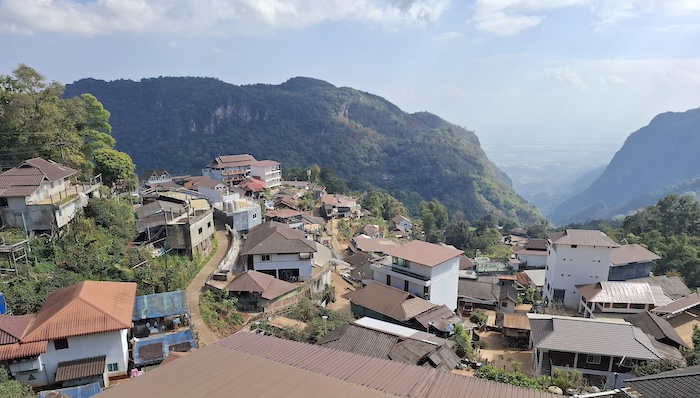
- Ban Pha Hee, partway along Route 1149.
The descent from the border to Highway 1 can be hard on brakes.
Doi Ang Khang Loop (Route 1249)
This 350 kilometre loop includes the 1815 metre high Doi Ang Khang Pass through the Daen Lao Range.
Marketed as Thailand’s ‘Little Switzerland’ because of its cool climate and mountain scenery it showcases caves, springs, Sri Sangwan waterfall (warning: it is in the Pha Daeng National Park), the Myanmar border, numerous viewpoints, and excellent mountain roads.
Route 1249 is a steep, zigzagging paved road with a maximum gradient of 19%. This crazy steep climb is on the Nor Lae-Fang back road and continues for approximately 400 metres .
Start/Finish: Chiang Mai
En Route Focal Points: Nor Lae, Fang
Distance: 350 kilometres
This is the best guide to riding the Ang Khang Loop – adapt as appropriate if driving.
The Floating Highway (Routes 1081 and 1256)
Regardless of the direction this Route is tackled the departure point is Pua. Head south on Route 1081 and see the famous number curves, 3 and 0 along the way. At Bo Luang leave Route 1081 and continue on Route 1256 back to Pua. The Floating Highway is a roughly circular, 120 kilometre route through the Luang Prabang Mountains.
-

- The ‘I Love U’ curve on Route 1081, Santi Suk, Nan Province.
The Floating Highway is also referred to as the ‘Road Above the Clouds’ and is often acclaimed as one of Thailand’s most beautiful roads.
There is no unanimity on which route carries the name The Floating Road/Highway and which is known as The Sky Road. This site is consistent in its naming – The Floating Highway R1081/1256 and The Sky Road R1148.
Gateway to South Asia
Route 12 from Tak to Mae Sot is an exhilarating drive through the Tenasserim Hills – the ‘Gateway to South Asia’.
-

- TAK TO MAE SOT ON ROUTE 12
The popular Doi Muser (Musoe) Markets at the top of the mountains are a welcome break along the 80 kilometre journey from Tak to Mae Sot, offering a short respite from the more than 200 bends in the journey, some of which are extremely tight.
-

- Doi Muser Hill Tribe Market.
-
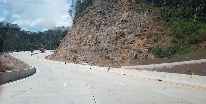
- The ‘Gateway to South Asia’ sweeps through the Tenasserim Hills/Dawna Range.
This Road Trip follows part of the more bureaucratically-named ‘East West Economic Corridor‘. This corridor is a 793 kilometre route through Thailand that links Laos at Suvakhannet/ Mukdahan (2nd Thai Laos Friendship Bridge) to Myanmar at Myawaddy/Mae Sot (1st Thai Myanmar Friendship Bridge).
-

- While for most of its length the Moei River forms the Thailand western border, the actual westernmost point is 124 kilometres further west and 244 kilometres further north on the Myanmar border.
The border town of Mae Sot is an interesting stopover with markets, restaurants and a number of POIs locally and nearby. It is the start point for an exciting, interesting and educational road trip north along Route 105 to Mai Sariang.
Mae Hong Son Loop
Probably the most famous ride/drive in Thailand, it is also known as the Chiang Mai Loop (Routes 108 and 1095). Totally suitable for four-wheeled vehicles.
There are dozens of ‘how to’ guides online.
The Mae Hong Son Loop starts and finishes at Chiang Mai and can be completed in either direction. Ex Chiang Mai south along Route 108, the major POIs are Mai Sariang, Mae Hong Son, and Pai.
The full distance of the Loop is 604 kilometres, however, numerous offshoots can add considerably to this tally. The three most worthwhile are Route 1266 to Ban Huai Hom, Rural Road 4001 to Ban Rak Thai, and Route 1265/1349 – a ‘shortcut’ to Chiang Mai.
There are numerous claims for the Mae Hong Son Loop being the twistiest route in Thailand. Don’t think so!
Number Shaped Road Curves
There are four locations in Thailand where the road engineering has described a numeral when viewed from the right position. Not unexpectedly these curves are located on Iconic Roads. It would seem that the Highways Department is not averse to the creation of more.
-

- An amazing piece of road engineering switches back on itself to form the shape of the numeral 9 on Route 2113, Na Haeo, Loei Province.
Paradise Highway
See Route 1290.
Road Above the Clouds
The Road Above the Clouds is another name for the Floating Highway. It is often acclaimed as one of Thailand’s most beautiful roads.
Route 105
-

- ROUTE 105 – MAE SOT TO MAE SARIANG
The route from Mae Sot to Mae Sariang is one of the great drives of Thailand.
For much of its length, the Moei River forms the border between Thailand and Myanmar. Route 105 broadly follows the Moei from Mae Sot to Baan Tha Song Yang at which point the road is routed further east until it finds its way to the course of the Yuam River.
Baan Mae La Refugee Camp is 57 kilometres north of Mae Sot and eight kilometres east of the Thai/Myanmar border.
There are up to 13 Police/Immigration Checkpoints between Mae Sot and Mae Hong Son. Some of these checkpoints are openly circumvented by people taking highly visible tracks through the forest. And the purpose of the Checkpoints is?
-

- Route 105 is one of the great drives of Thailand.
-

- The Moei River forms the border between Thailand and Myanmar for much of its length.
In the 230 kilometres of Route 105 between Mae Sot and Mae Sariang there are 947 bends.
The region traversed by Route 105 is populated by Hill Tribes. The very poor living conditions and older vehicles in the region are clearly noticeable. However, the presence of lots of big touring motorcycles and their riders confirm Route 105’s international status as a great ride, an iconic route, and well worth the effort to be able to say BTDT.
Route 1024
Route 1024 from Phrae is very steep, very twisty and quite remote. It is also a fantastic drive/ride. On our first trip along Route 1024 we stopped to watch and chat with some villagers husking and shelling corn on the side of the road.
-
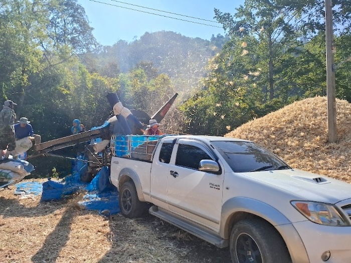
- Local villagers shelling corn on the side of Route 1024.
They advised us against taking our planned route which advice, thankfully, we ignored. While demanding attention and care, the route is totally worthwhile and leads to one of the great rides/drives of northern Thailand – Rural Road 4010 – acclaimed among riders of big, touring motorcycles.
Route 1026/1339 Shortcut
This interesting ride/drive starts where Route 1026 makes a turn east at the intersection with iconic Rural Road 4010 at Na Thanung. The 10000mile Bikers Cafe around the corner is confirmation you have taken the correct turn.
The Route weaves 77 kilometres through the Phi Pan Nam Range to the Pak Nai Fishing Village and then Nam Pat.
-

- Pak Nai Fishing Village
The main reason for taking this route if heading south is that it shortens the journey by many kilometres.
-
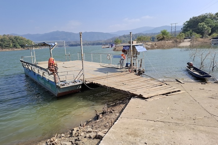
- Car Ferry at Pak Nai Fishng Village.
The car ferry at Pak Nai takes vehicles across an arm of Sirikit Reservoir, allowing more direct access to Nam Pat and ultimately a shorter journey to Phitsanulok.
-
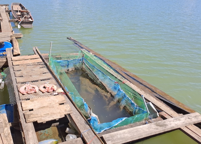
- Fish holding net and drying fish fish at Pak Nai.
From Pak Nai to Nam Pat the road is numbered Route 1339.
The journey from Na Noi to Phitsanulok (either east or west around Sirikit Reservoir) is 329 kilometres whereas going through Pak Nai reduces this to 264 kilometres.
Route 1081
Route 1081 starts at Pua. Heading south, the route takes in the famous Number 3 Curve and the Zero Curve.
-
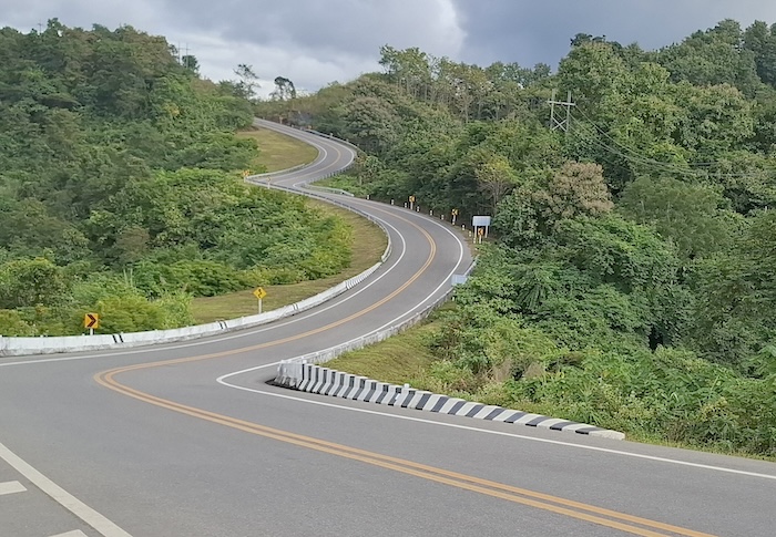
- Road Curve Number 3 on Route 1081 in Santi Suk, Nan Province.
The southern section of Route 1081 to Bo Luang is part of The Floating Highway. Route 1081 extends another 80 kilometres north from this point to its terminus at Route 101, for a total length of 155 kilometres.
There is no unanimity on which route carries the name The Floating Road/Highway and which is known as The Sky Road. This site is consistent in its naming – The Floating Highway R1081/1256 and The Sky Road R1148.
Route 1095
Route 1095 is part of the Mae Hong Song Loop. Often called “the road to Pai”. It runs from its intersection with R128 and R108 just north of Mae Hong Son through Pai to its western terminus with Route 107 at Chiang Mai – a distance of 205 kilometres.
-

- Viewpoint before Pai.
Route 1097
Iconic Route 1097 also lays claim to the best motorcycle road in Thailand. Along with Route 1148, Route 1081 and Route 1257 it is the heart of Nan. Spectacular scenery and great riding/driving conditions gives credence to the claim. The road straightens (relative term) on approach to Chiang Klang and Highway 101/AH13 – a major arterial highway through the mountain country.
Route 1148 (The Sky Road)
Route 1148 is a well-paved, winding mountain road that links the northern provinces of Nan and Phayao. Some claim it to be the ultimate motorcycle ride in the country, however, there are other claimants. Route 1148 is a great drive – 78 kilometres of mountainous scenery, interesting twists and turns, and some great viewpoints.
Ignore the uninformed comments that it is unpopulated (in Thailand??) with no refuels.
Paradise for bikers – although this is not Paradise Highway (Route 1290) – Route 1148, known by some as ‘The Sky Road’, is consistently recorded, reportedly, as one of the top ten motorcycle rides in the world.
Bikers don’t have all the fun – it is a great drive in a four wheeled vehicle.
There is no unanimity on which route carries the name The Floating Road/Highway and which is known as The Sky Road. This site is consistent in its naming – The Floating Highway R1081/1256 and The Sky Road R1148.
Route 1249
See Doi Ang Khang Loop.
Road 1256
With the southern portion of Route 1081 this road constitutes The Floating Highway. Number 3 Curve and Number 0 Curve are on the southern (R1081) portion of The Floating Highway.
There is no unanimity on which route carries the name The Floating Road/Highway and which is known as The Sky Road. This site is consistent in its naming – The Floating Highway R1081/1256 and The Sky Road R1148.
Route 1257
Dark, narrow, twisty, remote, steep, pot holed, testing. Great views. Now we’re getting into the real country Thailand. Experienced riders/drivers only. Box ticking ride/drive. A 32 kilometre imprint on the brain.
Route 1257 leaves Route 1081 heading south and ends at Santisuk. Do it.
Route 1265/1349
Combined with Route 1349 this is an alternative route to Chiang Mai – rather than travelling from Pai along Route 1095.
This little used route features numerous hot springs.
-
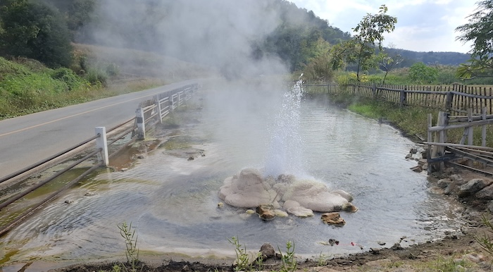
- Doimon Hot Spring alongside the Pai River.
To access Route 1265 turn south off Route 1095 about five kilometres out of Pai. Travel 44 kilometres to Ban Wat Chan – the finish of Route 1265 and the start of Route 1349.
Route 1266
The start of Route 1266 is about 29 kilometres north of Mae Sariang at its intersection with Highway 108 in Ban Mae La Noi.
Route 1266 runs eastward to Ban Huai Hom and Karen hill tribe communities. It is a winding mountain road with stunning views of expansive ranges, rice fields, and valleys.
The ride/drive offers demanding drives with steep, tight curves.
-

- Intersection of Routes 108 and 1266. 29 kilometres north of Mae Sariang.
A ride/drive along Route 1266 terminates past Ban Huai Hom and requires a return to Ban Mae La Noi.
Route 1268 (Duel Highway)
While not perhaps as technical a ride/drive as some of the roads in this list Route 1268 (part) is Included because of the truck-driving predator who haunts its hills, dips and curves making an unfortunate chance encounter with this maniac a scarily memorable and dangerous journey.
Duel Highway starts at Lao Ko Hok 27 kilometres west of Na Haeo and finishes at Phu Soi Dao Waterfall, a distance of only 35 kilometres. It is part of the longer Route 1268 that starts in Na Haeo and terminates at the intersection with Route 117, 120 kilometres to the north. It has 172 bends/curves in its length.
The name for this Highway derives from the 1971 Steven Spielberg-directed movie Duel – a masterclass in tension-building that created a genre modern efforts have yet to conquer. Why name a ‘highway’ after a movie?
Route 1290 (Paradise Road/Paradise Highway)
From its western terminus at Mae Sai (check out the nearby Skywalk at Wat Phra That Doi Wao), Route 1290 passes the Golden Triangle, ancient ruins at Chiang Saen, the infamous Golden Triangle Special Economic Zone (in Laos), and the spectacular Skywalk at Wat Phra That Pha Ngao in Chiang Saen district with views across the Mekong River.
-

- Convenient structure at which to take posed photographs of your visit to the Golden Triangle.
-
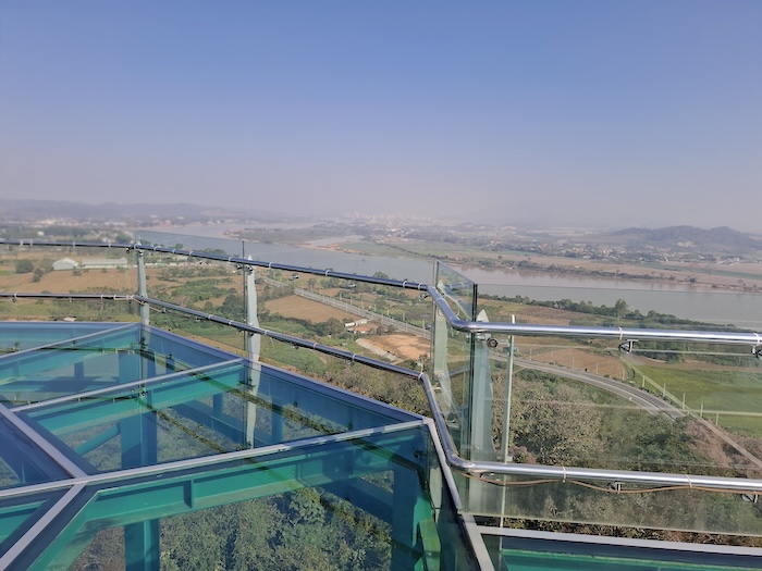
- Chiang Saen Skywalk.
-

- The infamous SEZ across the Mekong River in Laos.
The Eastern Terminus at R1020 allows access to the Bak Ferry Terminal (to Laos). Along the way this route has picked up the label of ‘Paradise Highway’.
Route 1349/1265
Combined with Route 1265 this is an alternative route to Chiang Mai – rather than travelling from Pai along Route 1095. It starts at Ban Wat Chan.
Rural Road มส4001 (Mae Hong Son Province)
Rural Road มส4001 starts at Pang Mu and gives access to Ban Rak Thai, a ‘Chinese’ village on the Thai/Myanmar border that was established in 1949 when a cohort of Kuomintang (Chinese Nationalists) fleeing the Mao Zedong’s communists left China through Laos and Burma to find refuge in northern Thailand. The town got its current name in 1984 – meaning ‘Love Thailand’.
After taking a few photographs there is little to do in Ban Rak Thai other than watch other people also wondering, “why am I here?” and maybe have some Thai food in the Chinese restaurant. It is a low grade tourist destination – despite what the effusive, pay-for-praise social media scribes may write – although the 34 kilometres of Rural Road มส4001 access road is a great drive. These ‘influencers’ admit that there is nothing to do in Ban Rak Thai and then attempt to make a virtue out of being bored.
-

- Lakeside accommodation at Ban Rak Thai.
Despite the paucity of reasons for tourists to visit Ban Rak Thai the great drive/ride in and out on Rural Road มส4001 is not one of them. Rural Road มส4001 to Ban Rak Thai is narrow, winding, steep, beautiful, and requires all your attention. It is a very worthwhile experience.
Rural Road มส4001 departs Route 108 to the west, five kilometres north of where Route 128 and Route 108 meet in Mae Hong Song. Rural Road มส4001 continues 34 kilometres to Ban Rak Thai. Pha Suea Waterfall is about halfway along the Route.
An alternative start point into Ban Rak Thai is to continue 15 kilometres north from the reunification of Route 128 and Route 108 and turn left a few metres before Thai Elephant Coffee and Souvenir Shop (selling Route Number stickers) on Route 108. Though this option traverses six fewer kilometres of Rural Road มส4001, it is still an incredible ride/drive and maybe the preferable option if intent on doing the entire Mae Hong Son Loop.
Rural Road มส.4001 (Mae Hong Son Province) is not the same as Route 4001 in Chumphon Province, an eight kilometre connector road that joins Highway 4 to Chumphon (Southern Thailand). Thailand’s Road System.
Rural Road มส4009 (Mae Hong Son Province)
Rural Road มส4009 leaves Route 1263, 12 kilometres east of Khun Yuam (on Route 108 – MHS Loop), in a northerly direction and describes a 54 kilometre circuit to join Route 108 twenty kilometres to the north near Ban Ma Cha.
The road is subject to landslides.
The extensive sunflower fields at Bua Tong, Doi Mae U Kho are the premier attraction of the region and a primary reason for taking this route. The strictly seasonal bloom time is November-December. A ‘sea of mist’ may be seen at vantage points along the route during the winter months.
The Mae Surin Waterfall National Park (a few hundred metres off the bitumen) is another attraction about midway along the ride/drive. Numerous Viewpoints provide a break from the hard riding/driving, including Doi Phu Chi Fa Viewpoint (not to be confused with the more famous Phu Chi Fa Viewpoint in Chiang Rai).
Rural Road มส.4009 (Mae Hong Son Province) is not the same as Route 4009 that connects Surat Thani southward to Ban Na San and Ban Na Doem in Surat Thani Province (southern Thailand). Thailand’s Road System.
Rural Road นน4010 (Nan Province)
Acclaimed among the riders of big touring motorcycles, this isolated route from Phrae into Nan Province may be subject to washouts, collapsed sections of roadway and rockfalls/landslides.
What was once a restaurant is on the outside of a bend at the Pak Huay Oi Viewpoint – overlooking the village of Pak Huay Oi. An abandoned mobile concrete mixer – that may or may not still be there – helps pinpoint the location.
What will be there five kilometres along the route is Ban Bun Yuen – home to a Mlabri Tribe. Visiting Mlabri, Htin or Khamu tribes may be raise ethical issues of ‘human zoo’ exploitation but the issue is way more problematic, particularly when tourism is the major source of income for a village – to go or not to go??
The western end of the road is the intersection with R1217/R1342 near Pak Huay Oi. The eastern terminus is 37 kilometres by road at Na Thanung (see Route 1026).
Rural Road นน4010 (Nan Province) is not the same as Route 4010 in Surat Thani. Thailand’s Road System.
Rural Road กจ4041 (Kanchanaburi Province)
The journey along Rural Road กจ4041 actually starts further south at the Sisawat Ferry, a six kilometre journey across an arm of the Sinakharin Dam that saves a 24 kilometre drive around the edge of the dam. It is then 10 kilometres north to the start of Rural Road กจ4041.

This description of the route along Rural Road กจ4041 up the mountains of Sinakharin Dam National Park and through the Tenasserim Hills emanates from a journey made during a tropical storm that turned the afternoon into darkness – creating a truly fearsome drive through driving rain, fog/low cloud, twisting, turning, narrow roads with landslips (very minor) happening in front of us in real time, past landslides on blind bends forcing passage on the wrong side of the road, no Armco on the right and near-vertical rock face on the left. The lack of oncoming vehicles made driving on the wrong side of the road on blind bends a little bit safer, but it was still not a good place to have anything go wrong.
-

- THROUGH THE TENASSERIM HILLS ON RURAL ROAD กจ4041.
While this unnerving section of road eventually straightens out there is even more twisting, turning, tension-inducing bends and switchbacks after Tha Lam Yai. The drive along Rural Road กจ4041 could not have been made in worse conditions so this description is a little coloured from what could be expected on, say, a bright sunny day in January.
Rural Road กจ.4041 has earned a genuine local reputation as an eerie, unsettling road to drive at night — a Thairath news piece profiles it explicitly as one of Thailand’s ‘haunted roads’. The repeated history of landslides adds to its disorienting and unnerving reputation.
Samoeng Loop
The Samoeng Loop starts and ends in Chiang Mai. It is about 100 kilometre long and goes through the town of Mae Rim, Mae Sa Valley and Samoeng town. It is an interesting Day Trip. Includes Routes 1096, 1269 and 1284.
The Sky Road
Reportedly, The Sky Road (Route 1148) is consistently recorded as one of the top ten motorcycle rides in the world.
There is no unanimity on which route carries the name The Floating Road/Highway and which is known as The Sky Road. This site is consistent in its naming – The Floating Highway R1081/1256 and The Sky Road R1148.
Thinanon Road
Thinanon Road is the official name of Route 213 running from Maha Sarakham to Sakhon Nakhom – a distance of 173 kilometres. For the pedants there is a break in the road naming at Kalasin. The name of the road honours Sai Thinanon, a former chief engineer of the Maha Sarakham highway district.
Ban Kaeng Ka-Am in Kalasin Province heralds the start of a spectacular drive through the Phu Phan Mountains – a stretch characterised by 90 bends including one full 180 degree switchback and seven tight turns through 180 degrees.
-

- PORTION OF THEENANON ROAD THROUGH THE PHU PHAN MOUNTAINS
The popular Sawoei Cliff Viewpoint appears just four kilometres into this mountain drive, soon after the route enters Sakhon Nakhom Province.
-
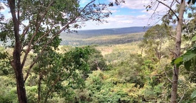
- The view from Sawoei Cliff.
A food vendor/fruit seller is almost mandatory at any Thai POI. Merch at the larger places!
And so it is at the Sawoei Cliff Viewpoint. A family sells cooked wild almonds among various fruits, drinks and other food. Around the world there are numerous trees known as wild almond. The Isaan variety is Irvingia malayana, prized for its seeds – the ‘wild almonds’ – and, apparently, its wood is ideal for construction, and for charcoal.
-

- Wild Almonds from north-east thailand.
Given Sawoei Cliff Viewpoint is such a popular tourist stop location the wild almonds are reasonably priced.
The first part of this mountain drive/ride finishes at Ban Na Yo. The next 37 kilometres of Thinanon Road is fairly straight and unremarkable – until the Khong Ping Ngu Curves.
These tight, looping switchbacks over the hills are said to resemble a snake, ‘curled as though it were skewered on bamboo and being grilled over a fire’.
Road engineers deliberately designed the curves to slow vehicle speeds on the descent, with the resulting shape coincidentally resembling the ‘grilled snake’ image. Giant kilometre-marker posts line the roadside here — reputedly among the largest in the country.
After this extraordinary piece of road engineering it is an easy 13 kilometre run into Sakhon Nakhom.
Thailand’s Four Principal Roads
The four principal roads of Thailand are identified by signage with a single digit. Each of these four roads connects the primate city of Bangkok to one of four outlying regions. By world standards they are very long, singularly-named roads.
Northern Thailand
Highway 1 (Phahonyothin Road)
Bangkok – Chiang Rai and continuing to Tachilek, Myanmar. Part of AH1/AH2.
North-Eastern Thailand
Highway 2 (Mittraphap Road)
Saraburi–Nong Khai as AH12.
Central, Western and Eastern Thailand
Highway 3 (Sukhumvit Road)
Bangkok–Trat as AH123.
Southern Thailand
Highway 4: (Phet Kasem Road)
Bangkok–Sadao via Hat Yai.
Thailand’s Road Numbering System
Highway Huts
No doubt you will see many of Thailand’s distinctive Highway Huts on your travels along the Iconic Roads listed here. There are more than 30,000 of these uniquely Thai structures nationwide.
Is this Thailand’s Twistiest Road?
If you are into motorcycle touring check out The GT Rider and MotoGirlThailand
© Kim Epton 2007-2026
3728 words, 18 photographs, three images.
Feel free to use any part of this document but please do the right thing and give attribution to adventures.net.au. It will enhance the SEO of your website/blog and Adventures.
See Terms of Use.