
ACROSS AUSTRALIA
Steep Point to Cape Byron
Australia’s Westernmost Point to Australia’s Easternmost Point
A four-vehicle, 7200 km 4WD journey across the breadth of Australia,
from Steep Point in Western Australia to Cape Byron in NSW,
from 1-25 August 2027.
1. Executive Summary
Across Australia is a four-vehicle 4WD Expedition between Australia’s westernmost and easternmost mainland points. The route covers ~7200 kilometres across Western Australia, the Northern Territory, South Australia, Queensland, and New South Wales.
The Expedition team comprises five participants travelling in a Suzuki Vitara modified trayback, and three Suzuki Jimny Wagons.
The human-interest angle of a mature-age team undertaking one of Australia’s great geographic traverses in small, ageing vehicles is considerable, proving that adventure is not the exclusive domain of the young.
Just as the expedition shows that adventure is not the exclusive domain of the young, it also shows that a great traverse is not the exclusive domain of new, expensive, oversized 4WDs.
The key challenge in this undertaking is to keep the vehicles roadworthy for a sustained period in difficult conditions. Foremost in this challenge is tyre damage, dirty fuel, wild animals, suspension failure, and overheating.
The date of the Expedition is 1 – 25 August 2027.
The Key Risks in undertaking this venture are the age of the vehicles, the age of the participants, the remoteness, and the duration, distance and time constraints of the trip.
Terminology – the journey from Steep Point to Cape Byron is termed the Expedition. The entire journey including the Expedition, the drive from Perth to Steep Point, and the return from Cape Byron to Perth is referred to as the Road Trip.
Four independently equipped 4WD vehicles carrying comprehensive communications gear, comprehensive recovery equipment, first aid capability, sufficient fuel and water reserves to operate safely and independently in remote areas, and crewed by more-than-competent personnel will ensure the Expedition succeeds in what is a noteworthy cross continent foray.
Success is seen as completion of the traverse of Australia from Steep Point to Cape Byron while maintaining participant safety and vehicle operability, all within budget.
Knowing What it Takes
The Navigator and Coordinator of this adventure, Kim Epton, was the first person to drive a much more difficult trip across Australia following the Tropic of Capricorn — vehicles supplied by Mitsubishi Australia, tyres from Bridgestone, sponsorship from Bob Jane T Marts, documentary by Channel 7 shown nationwide numerous times.
-
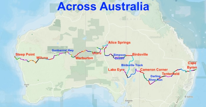
- ROUTE OF THE ACROSS AUSTRALIA EXPEDITION
2. Overview of Route
2.1 Why this Route
Many crossings of the continent between its two extremities do so in as short a line as possible and, often, in as short a time as possible.
Across Australia is not a race nor a record-breaking attempt. It is a private adventure pitting small, ageing vehicles against a big landmass.
The nature of the undertaking has a considerable effect on the route selected – see for instance the departure from a ‘straight line’ in the Red Centre/Central Australia, Cooper Country/Lake Eyre and the Corner Country/Darling River Run.
2.2 The Start Point at Steep Point
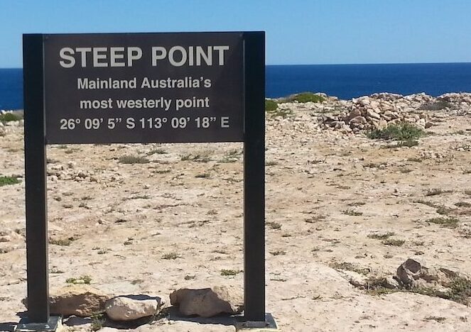
Steep Point, within the Shark Bay World Heritage Area, is Australia’s westernmost mainland point. It is the departure point for this Expedition for a number of practical reasons:
- Short run to the start point through familiar country.
- Travelling west to east means the team drives into the morning sun on early legs, not the setting sun on afternoon runs — a safety and comfort advantage on long daily drives.
- The ~1100 Simpson Desert dunes have a gentle western slope and a steep eastern face. Travelling west to east provides an easier windward climb that is far more manageable than the reverse.
- A number of post-Expedition highlights between Cape Byron and Perth will be undertaken and these could not be attempted if they were scheduled pre-Expedition.
2.3 The Expedition Route
The Expedition Route from Steep Point to Cape Byron is divided into 10 Sectors covering a distance of ~7200 kilometres. The Sectors are:
Murchison
Gunbarrel Highway
Great Central Road
Red Centre
Central Australia
Simpson Desert
Cooper Country
Corner Country
Darling River Run
Over the Great Divide
2.4 The Finish Point at Cape Byron
Cape Byron, near Byron Bay on the New South Wales north coast, is Australia’s easternmost mainland point. The cape is marked by the Cape Byron Lighthouse and sits within Cape Byron Marine Park and the Cape Byron Headland Reserve. There is general vehicle access to the lighthouse.
-

- Cape Byron Lighthouse.
More detailed information about the Route.
3. Itinerary
| Date | Event / Milestone |
| 29 July 2027 | Depart Perth. |
| 29 July 2027 | Arrive Steep Point — layday. |
| 1 August 2027 | Depart Steep Point. |
| 1-10 August 2027 | Legs 1–11: Steep Point to Alice Springs. |
| 13-25 August 2027 | Legs 13-31: Alice Springs to Cape Byron |
| 26 August 2027 | Layday in Cape Byron before commencing Post Expedition Road Trips. |
| 27 August 2027 | Post Expedition Road Trips. |
After Cape Byron
A number of iconic Road Trips that have been on participants’ ‘bucket list’ for years and are ‘sort of’ on the way back to Perth will be tackled after the Across Australia expedition.
Read more about the Post Expedition Road Trips.
4. Navigation
The Expedition will navigate from Steep Point to Cape Byron using Moving Map Software, backed up by digital maps and, as a final fallback, paper maps — which the participants, given their vintage, are still perfectly capable of reading.
Our plan so we don’t get lost is here.
5. Participants
| Name | Decision Making Roles | Notes |
| Kim Epton | Coordinator/Planning Navigation Media |
Pre – Route Planning During – Navigation, Diary Post – Photo essay |
| Cliff Hills | Vehicle Preparation/Mechanic | Pre – Vehicle preparation, Tools During – Vehicle Maintenance |
| Greg Barndon | Campsites/Communications | Pre – Vehicle Preparation During – Campsites, Vehicle Maintenance |
| Scott Overstone | Electrical/Route Planning | Pre – Vehicle Preparation During – Mechanical/Route Planning/ Sweep |
| Mike Crane | Catering/Medical/Insurance | Pre – Catering, insurance, Medical During – Cooking, Relief Driver |
6. Vehicles
The four vehicles will be professionally prepared by the owners, drawing extensively on their individual ten years’ experience in offroad racing and their individual 30 to 40 years in outback touring.
7. Fuel
The only real factor, the only factor of importance is range.
Because of varying conditions the range of the vehicles is not a constant number. It is estimated that it will vary from 540 km to 820 kilometres. Even the low number is still sufficient for the vehicles to cover the distance required.
Refuelling locations, quantities, receptacles, cost of fuel, opening hours are all details that can be worked around.
See Fuelling Plan.
8. Catering
The provision of healthy, nutritious and satisfying meals at regular times is considered of such importance on an extended venture such as Across Australia that the option to provide a dedicated cook as a part of the team has been included as an alternative to self catering.
See the Catering Plan.
9. Equipment
After experience in comparable expeditions and many years of outback touring the crew know what equipment is needed for Across Australia.
10. Communications
Communications Priority
- UHF Radio
- Mobile Phone
- Starlink
- Satellite Communicator
- PLB
Details of our Communications Plan.
11. Accommodation
Bush camping is the preferred option.
Caravan parks will be accessed, as available, every two to three days.
Details of all Accommodation Options during Expedition.
12. Vehicle Recovery
The knowledge, skills and expertise among the team is sufficient to overcome most mechanical issues ensuring self-recovery from most foreseeable incidents.
Nevertheless, formal recovery procedures have been developed for circumstances should self-recovery be non-feasible..
A Vehicle Recovery Plan has been devised to deal with vehicle mechanical/recovery issues.
13. Media and Publicity
Today’s media landscape is fractured and diverse. Attention that was once concentrated in a small number of newspapers, television networks, and specialist magazines is now spread across many channels — websites, social media platforms, podcasts, forums, and a few print titles that still maintain a loyal readership. No single placement reaches most of an audience the way it once did.
This plan sets out how the Across Australia expedition addresses that fragmentation and how it will be promoted across owned, earned, and paid channels, sequenced across three phases: pre-launch, during the expedition, and post-trip.
Live Stream of Expedition
Sponsorship from Advanced TMS has enabled live streaming of the entire Across Australia adventure.
In addition, Advanced TMS will track the Road Trip live.
Go to Live Streaming.
See the detailed Promotion Plan.
14. Finance and Funding
14.1 Budget Categories
Fuel
Accommodation
Food
Medical/Travel Insurance
Comms
Recovery
Contingency
Go to Budget.
14.2 Funding Strategy
Participants fund their own:
-
- vehicle preparation costs.
- fuel usage costs.
- mechanical breakdown/repair costs
- insurance costs
Group costs split equally among participants.
Sponsorship will be sought to partially defray costs.
15. Daily Operating Procedures
Morning Routine
-
-
- Vehicle inspection
- Fuel check
- Water check
- Route briefing
-
Evening Routine
-
-
- Vehicle inspection
- Refuel before camp and where possible
-
More detailed Routines and Procedures are in Operations Plan.
16. Medical Plan
A detailed Medical Plan has been prepared that establishes procedures, responsibilities, equipment requirements and emergency response arrangements for managing illness and injury during the Across Australia Expedition.
The objective is to:
- Prevent avoidable medical incidents.
- Provide immediate treatment in remote areas.
- Facilitate rapid communication with emergency services.
- Enable safe evacuation where required.
- Protect the health and wellbeing of all participants.
17. Risk Register and Risk Management Plan
The entire Road Trip has been subject to a risk audit and a resultant Risk Register and Risk Management Plan has been formulated.
An example of some possible risks:
| Risk | Likelihood | Consequence | Control |
| Tyre failure | High | Medium | Tyre repair kits, spare tyres |
| Fuel contamination | Medium | High | Fuel filtration |
| Vehicle rollover | Low | Extreme | Driver discipline |
| Medical emergency | Medium | Extreme | Medical plan, evacuation |
| Wildlife collision | Medium | High | Daylight driving |
| Heat illness | Medium | High | Hydration procedures |
The Risk Register and Risk Management Plan will be updated before departure.
18. Go/No Go Criteria
- Participant medically unfit/dies and cannot be replaced.
- Critical permits not obtained.
- Insufficient funding available.
Incomplete vehicle preparation will trigger a postponement of Across Australia not an abandonment. The window extends to September.
Track closures are the most likely impediment and in these circumstances the Expedition will be re-routed.
During Expedition
Expedition modified or halted if:
-
-
- Two vehicles become non-operational.
- Medical emergency occurs.
- Route closure prevents progress.
- Fuel availability becomes uncertain.
-
19. Operations Plan
The Operations Plan is how the Expedition will run. It drives all other actions and procedures.
© Kim Epton 2026
1696 words written entirely by the author, not AI.
You are welcome to use any part of this document. Please attribute adventures.net.au — it will help your site’s SEO as well as that of adventures.net.au
See Terms of Use.